
Gracias por apoyar a este sitio ❤️
Haz una donación
Haz una donación
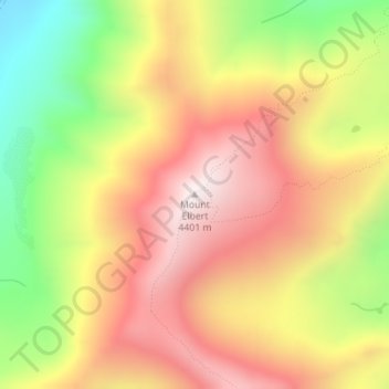
Mapa topográfico Mount Elbert
Haga clic en el mapa para ver la altitud.
Gracias por apoyar a este sitio ❤️
Haz una donación
Haz una donación
Mount Elbert
El monte Elbert se encuentra en la cordillera Sawatch que pertenece al gran sistema de cordilleras de las Montañas Rocosas. Está compuesto principalmente de cuarcita, aunque el pico está formado por un zócalo de rocas metamórficas de origen precámbrico de unos 1.700 millones de años de antigüedad. A diferencia de la mayoría de las montañas de su altitud, el monte Elbert no tiene nieves permanentes, lo que puede ser atribuido a que no recibe muchas precipitaciones, como consecuencia de que se encuentra entre otras montañas de gran altitud.
Gracias por apoyar a este sitio ❤️
Haz una donación
Haz una donación
Acerca de este mapa
Nombre: Mapa topográfico Mount Elbert, altitud, relieve.
Altitud media: 3.959 m
Altitud mínima: 3.422 m
Altitud máxima: 4.394 m
Gracias por apoyar a este sitio ❤️
Haz una donación
Haz una donación