
Gracias por apoyar a este sitio ❤️
Haz una donación
Haz una donación
Mapa topográfico Corfú
Haga clic en el mapa para ver la altitud.
Gracias por apoyar a este sitio ❤️
Haz una donación
Haz una donación
Corfú
La longitud de la isla es de 85 km, con un ancho promedio de 18 km. Su relieve es muy accidentado, si bien pueden distinguirse dos zonas: la septentrional, mucho más abrupta, donde se encuentra la máxima cumbre: el monte Pantocrátor o Salvador (Όρος Παντοκράτωρας, Óros Pandokrátoras) con 906 m de altitud. La zona meridional es considerablemente menos accidentada, poseyendo algunas pequeñas llanuras.
Gracias por apoyar a este sitio ❤️
Haz una donación
Haz una donación
Acerca de este mapa
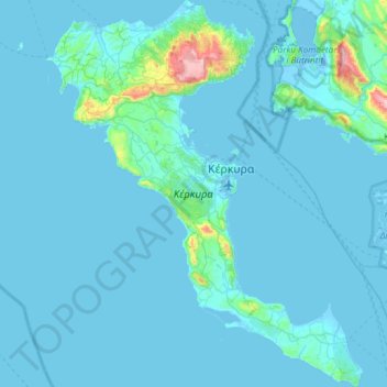
Nombre: Mapa topográfico Corfú, altitud, relieve.
Altitud media: 41 m
Altitud mínima: -7 m
Altitud máxima: 888 m
Gracias por apoyar a este sitio ❤️
Haz una donación
Haz una donación