
Mapa topográfico Lake Ontario
Mapa interactivo
Haga clic en el mapa para ver la altitud.
Lake Ontario
Lake Ontario is the easternmost of the Great Lakes and the smallest in surface area (7,340 sq mi, 18,960 km2), although it exceeds Lake Erie in volume (393 cu mi, 1,639 km3). It is the 13th largest lake in the world. When its islands are included, the lake's shoreline is 712 miles (1,146 km) long. As the last lake in the Great Lakes' hydrologic chain, Lake Ontario has the lowest mean surface elevation of the lakes at 243 feet (74 m) above sea level; 326 feet (99 m) lower than its neighbor upstream. Its maximum length is 193 statute miles (311 kilometres; 168 nautical miles) and its maximum width is 53 statute miles (85 km; 46 nmi). The lake's average depth is 47 fathoms 1 foot (283 ft; 86 m), with a maximum depth of 133 fathoms 4 feet (802 ft; 244 m). The lake's primary source is the Niagara River, draining Lake Erie, with the St. Lawrence River serving as the outlet. The drainage basin covers 24,720 square miles (64,030 km2). As with all the Great Lakes, water levels change both within the year (owing to seasonal changes in water input) and among years (owing to longer-term trends in precipitation). These water level fluctuations are an integral part of lake ecology, and produce and maintain extensive wetlands. The lake also has an important freshwater fishery, although it has been negatively affected by factors including over-fishing, water pollution and invasive species.
Acerca de este mapa
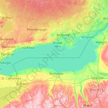
Nombre: Mapa topográfico Lake Ontario, altitud, relieve.
Lugar: Lake Ontario, Ontario, Canada (43.15936 -79.92534 44.36087 -76.00101)
Altitud media: 215 m
Altitud mínima: 70 m
Altitud máxima: 679 m
Otros mapas topográficos
Haga clic en un mapa para ver su topografía, su altitud y su relieve.
Dog Lake
Canada > Ontario > Thunder Bay District > Unorganized Thunder Bay District
Altitud media: 310 m
Shabuskwia Lake
Canada > Ontario > Thunder Bay District > Unorganized Thunder Bay District
Altitud media: 332 m
London
London has a humid continental climate (Köppen Dfb), though due to its downwind location relative to Lake Huron and elevation changes across the city, it is virtually on the Dfa/Dfb (hot summer) boundary favouring the former climate zone to the southwest of the confluence of the South and North Thames Rivers,…
Altitud media: 269 m
Apple Hill
Canada > Ontario > Stormont, Dundas and Glengarry Counties > North Glengarry
Altitud media: 90 m
Toronto
Despite its deep ravines, Toronto is not remarkably hilly, but its elevation does increase steadily away from the lake. Elevation differences range from 76.5 metres (251 ft) above sea level at the Lake Ontario shore to 209 m (686 ft) ASL near the York University grounds in the city's north end at the…
Altitud media: 113 m