
Mapa topográfico Consett
Mapa interactivo
Haga clic en el mapa para ver la altitud.
Acerca de este mapa
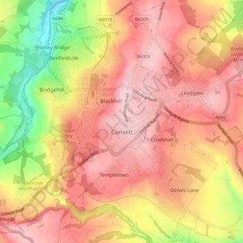
Nombre: Mapa topográfico Consett, altitud, relieve.
Lugar: Consett, County Durham, North East, England, United Kingdom (54.82807 -1.88241 54.88004 -1.80089)
Altitud media: 205 m
Altitud mínima: 80 m
Altitud máxima: 277 m
Otros mapas topográficos
Haga clic en un mapa para ver su topografía, su altitud y su relieve.
Mickle Fell
United Kingdom > England > County Durham
Mickle Fell is a mountain in the Pennines, the range of hills and moors running down the middle of Northern England. It has a maximum elevation of 788 m (2,585 ft). It lies slightly off the main watershed of the Pennines, about 10 miles (16 kilometres) south of Cross Fell. After Cross Fell, Mickle Fell is the…
Altitud media: 658 m
West Shield Row Villas
United Kingdom > England > County Durham > Stanley > Tanfield Lea
Altitud media: 180 m
High Shincliffe
United Kingdom > England > County Durham
High Shincliffe is a village in County Durham, England. It is situated about two miles south-east of Durham City, on the A177 road to Stockton-on-Tees. The altitude of High Shincliffe is approximately 90 metres (300 ft), and it lies 55 metres (180 ft) above the River Wear at Shincliffe bridge. Latest…
Altitud media: 77 m
Bishop Middleham Quarry Nature Reserve
United Kingdom > England > County Durham > Bishop Middleham
Altitud media: 115 m
West Butsfield
United Kingdom > England > County Durham > Satley > West Butsfield
Altitud media: 259 m
Copley
United Kingdom > England > County Durham
Copley has its own weather station run by the Met Office and Environment Agency. Because of its elevation above sea-level, around the 1,000 ft contour, and position in the north-east, this station is often one of the coldest in England with high incidences of ground frosts and snowfalls. Copley is in a…
Altitud media: 261 m