
Mapa topográfico Jersey
Mapa interactivo
Haga clic en el mapa para ver la altitud.
Jersey
Jersey is an island measuring 118.2 square kilometres (45.6 sq mi) (or 66,436 vergées), including reclaimed land and intertidal zone. It lies in the English Channel, about 12 nautical miles (22 km; 14 mi) from the Cotentin Peninsula in Normandy, France, and about 87 nautical miles (161 km; 100 mi) south of Great Britain. It is the largest and southernmost of the Channel Islands, with a maximum land elevation of 143 m (469 ft) above sea level.
Acerca de este mapa
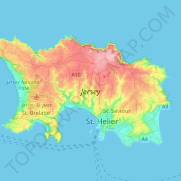
Nombre: Mapa topográfico Jersey, altitud, relieve.
Lugar: Jersey, Saint Lawrence, Jersey (49.16252 -2.25451 49.26213 -2.01042)
Altitud media: 25 m
Altitud mínima: -2 m
Altitud máxima: 135 m