
Mapa topográfico Arches National Park
Mapa interactivo
Haga clic en el mapa para ver la altitud.
Acerca de este mapa
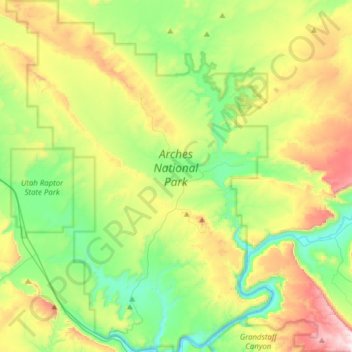
Nombre: Mapa topográfico Arches National Park, altitud, relieve.
Lugar: Arches National Park, Grand County, Utah, United States (38.60474 -109.71320 38.84693 -109.47771)
Altitud media: 1.476 m
Altitud mínima: 1.206 m
Altitud máxima: 1.995 m
The park consists of 310.31 square kilometres (76,680 acres; 119.81 sq mi; 31,031 ha) of high desert located on the Colorado Plateau. The highest elevation in the park is 5,653 feet (1,723 m) at Elephant Butte, and the lowest elevation is 4,085 feet (1,245 m) at the visitor center. The park receives an average of less than 10 inches (250 mm) of rain annually.
Otros mapas topográficos
Haga clic en un mapa para ver su topografía, su altitud y su relieve.
Moab
United States > Utah > Grand County
Moab, Grand County, Utah, 84532, United States
Altitud media: 1.357 m
Westwater
United States > Utah > Grand County
Westwater, Grand County, Utah, United States
Altitud media: 1.349 m
Cisco
United States > Utah > Grand County
Cisco, Grand County, Utah, 84515, United States
Altitud media: 1.334 m
Rectory
United States > Utah > Grand County
Rectory, Grand County, Utah, United States
Altitud media: 1.527 m
Delicate Arch
United States > Utah > Grand County
Delicate Arch, Delicate Arch Trail, Grand County, Utah, United States
Altitud media: 1.409 m
Thompson Springs
United States > Utah > Grand County
Thompson Springs, Grand County, Utah, 84540, United States
Altitud media: 1.583 m
Colorado River
United States > Utah > Grand County > Moab
Colorado River, Moab, Grand County, Utah, United States
Altitud media: 1.668 m
Castle Valley
United States > Utah > Grand County
Castle Valley, Grand County, Utah, United States
Altitud media: 1.610 m
Cottonwood Point
United States > Utah > Grand County
Cottonwood Point, Grand County, Utah, United States
Altitud media: 2.346 m
La Sal Mountains Viewpoint
United States > Utah > Grand County
La Sal Mountains Viewpoint, Main Park Road, Grand County, Utah, 84532-2134, United States
Altitud media: 1.347 m