
Mapa topográfico Hartford
Mapa interactivo
Haga clic en el mapa para ver la altitud.
Acerca de este mapa
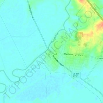
Nombre: Mapa topográfico Hartford, altitud, relieve.
Lugar: Hartford, Ohio County, Kentucky, United States (37.43446 -86.91460 37.46950 -86.87671)
Altitud media: 123 m
Altitud mínima: 115 m
Altitud máxima: 155 m
Several elements of the Downtown Hartford Historic District, including the courthouse, jail and main block of the Hartford City Hall, remain virtually intact on the exterior. As in most downtowns, however, storefronts have suffered the greatest changes. Fortunately, most of the upper elevations of these buildings have been well preserved so that the district's streetscape retains its historic character. Despite alterations, the district remains a visually distinct entity due to the extensively renovated older buildings and new construction that define its edges.
Otros mapas topográficos
Haga clic en un mapa para ver su topografía, su altitud y su relieve.
No Creek
United States > Kentucky > Ohio County
No Creek, Ohio County, Kentucky, United States
Altitud media: 129 m
Olaton
United States > Kentucky > Ohio County
Olaton, Ohio County, Kentucky, 42361, United States
Altitud media: 157 m
Fordsville
United States > Kentucky > Ohio County > Fordsville
Fordsville, Ohio County, Kentucky, United States
Altitud media: 163 m