
Haz una donación
Mapa topográfico Escondido
Haga clic en el mapa para ver la altitud.
Haz una donación
Escondido
Escondido has a borderline semi-arid climate (Köppen: Bsh) and hot-summer Mediterranean climate (Köppen: Csa) with hot summers and cool wet winters. Owing to its inland setting it is considerably warmer than coastal cities like San Diego, Carlsbad or Oceanside during the summertime, and cooler in the winter. Yearly precipitation averages around 15 inches (380 mm) and can vary considerably from year to year. Rainfall totals are higher in the hills to the north and east, with 20-24 inches falling in most areas above 2,000 feet elevation, and over 30 inches on Palomar Mountain, 15 miles east. More than 80% of all precipitation takes place from November through March. Snow is virtually unheard of, though occasionally winter and springtime thunderstorms will drop small hail. The climate is mild enough to allow widespread cultivation of avocados and oranges. Escondido is located in a plant hardiness zone 10a. The hottest temperature recorded in Escondido was 115 °F on September 6, 2020. The coldest temperature recorded in Escondido was 13 °F on January 2, 1901, and January 7, 1913.
Haz una donación
Acerca de este mapa
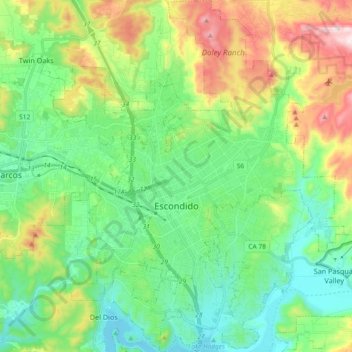
Nombre: Mapa topográfico Escondido, altitud, relieve.
Lugar: Escondido, San Diego County, California, United States (33.05766 -117.14612 33.21162 -116.99388)
Altitud media: 273 m
Altitud mínima: 87 m
Altitud máxima: 703 m
Haz una donación
Otros mapas topográficos
Haga clic en un mapa para ver su topografía, su altitud y su relieve.
Ramona
United States > California > San Diego County
In January 2006, Ramona Valley was designated the country's 162nd American Viticultural Area (AVA) by the Alcohol and Tobacco Tax and Trade Bureau, which recognized the area for its distinctive microclimate, elevation, and soil attributes.
Altitud media: 469 m
Rancho Peñasquitos
United States > California > San Diego County > San Diego
The highest point in the community is Black Mountain, which rises to an elevation of 1,500 feet (460 m).
Altitud media: 157 m
Haz una donación
Haz una donación
Lake Murray Reservoir
United States > California > San Diego County > San Diego > San Carlos
Altitud media: 178 m
Haz una donación
Haz una donación
Haz una donación
Haz una donación
Haz una donación
4S Ranch
United States > California > San Diego County
4S Ranch is underlain by Jurassic Santiago Peak Volcanics, Tertiary Stadium conglomerate, and slope wash alluvium. The land of 4S Ranch before development consisted of a variety of landforms ranging from nearly flat-lying mesas and gently rolling hills to rugged, steeply-sloping hillside terrain. Elevations…
Altitud media: 183 m
San Diego
United States > California > San Diego County > San Diego
The climate in San Diego, like most of Southern California, often varies significantly over short geographical distances, resulting in microclimates. In San Diego, this is mostly because of the city's topography (the Bay, and the numerous hills, mountains, and canyons). Frequently, particularly during the "May…
Altitud media: 57 m
Haz una donación
Haz una donación
Torrey Pines State Natural Reserve
United States > California > San Diego County > San Diego
Altitud media: 37 m
Haz una donación
Case Spring
United States > California > San Diego County > Marine Corps Base Camp Pendleton
Altitud media: 687 m
Haz una donación
Haz una donación
Haz una donación
Haz una donación
Haz una donación
Pala
United States > California > San Diego County
The community is in the Pacific time zone. Pala is at an altitude of 404 feet, located at 33°21′55″N 117°04′36″W / 33.36528°N 117.07667°W / 33.36528; -117.07667 (latitude 33.365N, longitude 117.075W).
Altitud media: 189 m
Haz una donación
Flynn Springs County Park
United States > California > San Diego County > El Cajon > Flinn Springs
Altitud media: 330 m
Haz una donación
Haz una donación
Las Flores
United States > California > San Diego County > Marine Corps Base Camp Pendleton
Altitud media: 21 m
Haz una donación
Haz una donación
Camp Pendleton
United States > California > San Diego County > Marine Corps Base Camp Pendleton
Altitud media: 24 m
Haz una donación
Pine Valley
United States > California > San Diego County
Pine Valley is named for the locally unique strand of Jeffrey pine (Pinus jeffreyi) found along Pine Valley Creek, a seasonal drainage in the foothills of the Laguna Mountains in central San Diego County. According to the United States Geological Survey, Pine Valley is located 3,736 feet (1,139 m) above sea…
Altitud media: 1.291 m
Haz una donación
Haz una donación