
Mapa topográfico Eisenach
Mapa interactivo
Haga clic en el mapa para ver la altitud.
Acerca de este mapa
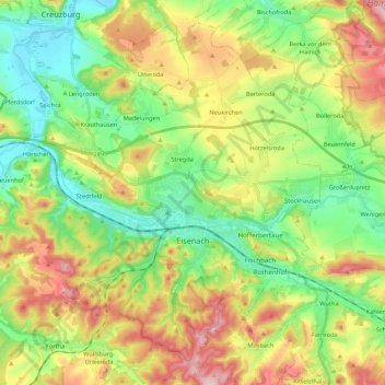
Nombre: Mapa topográfico Eisenach, altitud, relieve.
Lugar: Eisenach, Wartburgkreis, Thuringia, 99817, Germany (50.93081 10.17524 51.05239 10.39152)
Altitud media: 298 m
Altitud mínima: 190 m
Altitud máxima: 468 m
Eisenach is situated at the northern edge of the Thuringian Forest, at an elevation of about 220 m. The terrain is hilly, to the south also mountainous (up to 460 m of elevation), with the central Hörsel valley crossing the town in east-western direction. The Nesse river enters the Hörsel river in Eisenach after forming a valley through the spur of the Hörselberg mountains in the eastern municipal territory. The northern territory around the Neunkirchen, Stregda and Hötzelsroda districts is relatively flat and in agricultural use. Approximately 7 km (4 mi) west of the town centre runs the wide Werra valley, where the Hörsel river enters this bigger river near Hörschel district. The southern municipal territory is covered with forest, same as some smaller parts north of the Hörsel river. The Hainich mountains begin 10 km (6 mi) north-east of Eisenach.
Otros mapas topográficos
Haga clic en un mapa para ver su topografía, su altitud y su relieve.
Geisa
Germany > Thuringia > Wartburgkreis > Geisa
Geisa, Wartburgkreis, Thuringia, 36419, Germany
Altitud media: 332 m
Ramsberg
Germany > Thuringia > Wartburgkreis > Lauterbach
Ramsberg, Lauterbach, Hainich-Werratal, Wartburgkreis, Thuringia, 99826, Germany
Altitud media: 324 m
Bad Salzungen
Germany > Thuringia > Wartburgkreis
Bad Salzungen, Wartburgkreis, Thuringia, Germany
Altitud media: 347 m
Gerstungen
Germany > Thuringia > Wartburgkreis
Gerstungen, Wartburgkreis, Thuringia, 99834, Germany
Altitud media: 302 m
Bad Liebenstein
Germany > Thuringia > Wartburgkreis
Bad Liebenstein, Wartburgkreis, Thuringia, Germany
Altitud media: 424 m
Walkes
Germany > Thuringia > Wartburgkreis > Geisa
Walkes, Geisa, Wartburgkreis, Thuringia, Germany
Altitud media: 487 m