
Mapa topográfico Boise
Mapa interactivo
Haga clic en el mapa para ver la altitud.
Acerca de este mapa
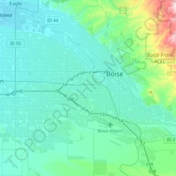
Nombre: Mapa topográfico Boise, altitud, relieve.
Lugar: Boise, Ada County, Idaho, United States (43.50940 -116.36568 43.69206 -116.09419)
Altitud media: 900 m
Altitud mínima: 773 m
Altitud máxima: 1.737 m
Boise (locally /ˈbɔɪsi/ (listen) BOY-see) is the capital and most populous city of the U.S. state of Idaho and is the county seat of Ada County. As of the 2020 census, there were 235,684 people residing in the city. On the Boise River in southwestern Idaho, it is 41 miles (66 km) east of the Oregon border and 110 miles (177 km) north of the Nevada border. The downtown area's elevation is 2,704 feet (824 m) above sea level.
Otros mapas topográficos
Haga clic en un mapa para ver su topografía, su altitud y su relieve.
Eagle
United States > Idaho > Ada County
Eagle, Ada County, Idaho, 83616, United States
Altitud media: 851 m
Hidden Springs
United States > Idaho > Ada County
Hidden Springs, Ada County, Idaho, United States
Altitud media: 912 m
Meridian
United States > Idaho > Ada County
Meridian, Ada County, Idaho, United States
Altitud media: 802 m