
Mapa topográfico Effingham
Mapa interactivo
Haga clic en el mapa para ver la altitud.
Acerca de este mapa
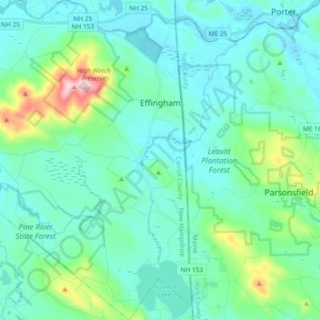
Nombre: Mapa topográfico Effingham, altitud, relieve.
Altitud media: 188 m
Altitud mínima: 110 m
Altitud máxima: 571 m
According to the United States Census Bureau, the town of Effingham has a total area of 39.9 square miles (103.4 km2), of which 38.8 square miles (100.4 km2) are land and 1.2 square miles (3.0 km2) are water, comprising 2.87% of the town. Green Mountain, elevation 1,884 feet (574 m), is the highest point in town. Effingham is drained by the Ossipee River and the Ossipee's tributaries, the Pine and South rivers. Province Lake lies partially within the town's borders to the south, and small portions of Ossipee Lake (Broad Bay and Berry Bay) are contained to the north. The community is bounded on the east by the Maine state line, and on the north by the Ossipee River. Effingham lies fully within the Saco River watershed. The Ossipee River subwatershed, partially in Effingham, is home to the largest stratified-drift aquifer in New Hampshire. Much of Effingham's land serves as aquifer recharge areas.
Otros mapas topográficos
Haga clic en un mapa para ver su topografía, su altitud y su relieve.
Conway
United States > New Hampshire > Carroll County
Conway, Carroll County, New Hampshire, United States
Altitud media: 256 m
North Conway
United States > New Hampshire > Carroll County > Conway
North Conway, Conway, Carroll County, New Hampshire, 03860, United States
Altitud media: 173 m
Big Attitash Mountain
United States > New Hampshire > Carroll County > Bartlett
Big Attitash Mountain, Bartlett, Carroll County, New Hampshire, United States
Altitud media: 711 m
Eidelweiss Beach
United States > New Hampshire > Carroll County > Madison
Eidelweiss Beach, Madison, Carroll County, New Hampshire, United States
Altitud media: 236 m
East Wakefield
United States > New Hampshire > Carroll County > Wakefield
East Wakefield, Wakefield, Carroll County, New Hampshire, 03830, United States
Altitud media: 206 m
Brookfield
United States > New Hampshire > Carroll County
Brookfield, Carroll County, New Hampshire, United States
Altitud media: 235 m
Center Conway
United States > New Hampshire > Carroll County > Conway
Center Conway, Conway, Carroll County, New Hampshire, 03813, United States
Altitud media: 142 m
Albany
United States > New Hampshire > Carroll County
Albany, Carroll County, New Hampshire, United States
Altitud media: 329 m
Melvin Village
United States > New Hampshire > Carroll County > Tuftonboro
Melvin Village, Tuftonboro, Carroll County, New Hampshire, 03850, United States
Altitud media: 181 m
Ferncroft
United States > New Hampshire > Carroll County
Ferncroft, Albany, Carroll County, New Hampshire, 03897, United States
Altitud media: 439 m
Center Sandwich
United States > New Hampshire > Carroll County > Sandwich
Center Sandwich, Sandwich, Carroll County, New Hampshire, 03227, United States
Altitud media: 227 m
Lees Mill
United States > New Hampshire > Carroll County > Moultonborough
Lees Mill, Moultonborough, Carroll County, New Hampshire, 03254, United States
Altitud media: 173 m
Wolfeboro Falls
United States > New Hampshire > Carroll County > Wolfeboro
Wolfeboro Falls, Wolfeboro, Carroll County, New Hampshire, 03894, United States
Altitud media: 181 m
Union
United States > New Hampshire > Carroll County > Wakefield
Union, Wakefield, Carroll County, New Hampshire, 03887, United States
Altitud media: 176 m
Kearsarge
United States > New Hampshire > Carroll County > Conway
Kearsarge, Conway, Carroll County, New Hampshire, 03847, United States
Altitud media: 272 m
Center Ossipee
United States > New Hampshire > Carroll County > Ossipee
Center Ossipee, Ossipee, Carroll County, New Hampshire, 03814, United States
Altitud media: 157 m
Chocorua
United States > New Hampshire > Carroll County > Tamworth
Chocorua, Tamworth, Carroll County, New Hampshire, 03817, United States
Altitud media: 202 m
Redstone
United States > New Hampshire > Carroll County > Conway
Redstone, Conway, Carroll County, New Hampshire, 03860, United States
Altitud media: 185 m
Silver Lake
United States > New Hampshire > Carroll County > Madison
Silver Lake, Madison, Carroll County, New Hampshire, United States
Altitud media: 162 m
West Ossipee
United States > New Hampshire > Carroll County > Ossipee
West Ossipee, Ossipee, Carroll County, New Hampshire, 03890, United States
Altitud media: 167 m
Hart's Location
United States > New Hampshire > Carroll County
Hart's Location, Carroll County, New Hampshire, United States
Altitud media: 706 m
Wonalancet
United States > New Hampshire > Carroll County > Tamworth
Wonalancet, Tamworth, Carroll County, New Hampshire, 03897, United States
Altitud media: 391 m
South Tamworth
United States > New Hampshire > Carroll County > Tamworth
South Tamworth, Tamworth, Carroll County, New Hampshire, 03883, United States
Altitud media: 265 m
Wolfeboro
United States > New Hampshire > Carroll County
Wolfeboro, Carroll County, New Hampshire, United States
Altitud media: 213 m
Flat Mountain
United States > New Hampshire > Carroll County > Sandwich
Flat Mountain, Sandwich, Carroll County, New Hampshire, United States
Altitud media: 629 m
Ossipee
United States > New Hampshire > Carroll County
Ossipee, Carroll County, New Hampshire, United States
Altitud media: 217 m
Lake Wentworth
United States > New Hampshire > Carroll County > Wolfeboro
Lake Wentworth, Wolfeboro, Carroll County, New Hampshire, United States
Altitud media: 180 m
Ossipee Lake
United States > New Hampshire > Carroll County > Freedom
Ossipee Lake, Freedom, Carroll County, New Hampshire, United States
Altitud media: 127 m
East Freedom
United States > New Hampshire > Carroll County > Freedom
East Freedom, Freedom, Carroll County, New Hampshire, United States
Altitud media: 144 m
South Chatham
United States > New Hampshire > Carroll County > Chatham
South Chatham, Chatham, Carroll County, New Hampshire, United States
Altitud media: 163 m
Mount Chocorua
United States > New Hampshire > Carroll County > Albany
Mount Chocorua, Albany, Carroll County, New Hampshire, United States
Altitud media: 736 m
Sawyers River
United States > New Hampshire > Carroll County > Hart's Location
Sawyers River, Hart's Location, Carroll County, New Hampshire, United States
Altitud media: 457 m
Wakefield
United States > New Hampshire > Carroll County
Wakefield, Carroll County, New Hampshire, United States
Altitud media: 218 m
Moultonborough
United States > New Hampshire > Carroll County
Moultonborough, Carroll County, New Hampshire, United States
Altitud media: 243 m
Goose Corner
United States > New Hampshire > Carroll County > Wolfeboro
Goose Corner, Wolfeboro, Carroll County, New Hampshire, 03984, United States
Altitud media: 189 m
Glen
United States > New Hampshire > Carroll County > Bartlett
Glen, Bartlett, Carroll County, New Hampshire, 03838, United States
Altitud media: 240 m
Sandwich
United States > New Hampshire > Carroll County
Sandwich, Carroll County, New Hampshire, 03259, United States
Altitud media: 373 m
Mount Washington Valley
United States > New Hampshire > Carroll County > Conway > North Conway
Mount Washington Valley, North Conway, Conway, Carroll County, New Hampshire, 03860, United States
Altitud media: 250 m
Tuftonboro
United States > New Hampshire > Carroll County
Tuftonboro, Carroll County, New Hampshire, United States
Altitud media: 256 m
Bill Rae Conservation Area
United States > New Hampshire > Carroll County > Wolfeboro > Stockbridge Corner
Bill Rae Conservation Area, Stockbridge Corner, Wolfeboro, Carroll County, New Hampshire, United States
Altitud media: 244 m
Brookfield
United States > New Hampshire > Carroll County > Brookfield
Brookfield, Carroll County, New Hampshire, 03872, United States
Altitud media: 195 m
Mount Willard
United States > New Hampshire > Carroll County > Hart's Location
Mount Willard, Hart's Location, Carroll County, New Hampshire, United States
Altitud media: 775 m
North Sandwich
United States > New Hampshire > Carroll County > Sandwich
North Sandwich, Sandwich, Carroll County, New Hampshire, 03259, United States
Altitud media: 233 m
Sanbornville
United States > New Hampshire > Carroll County > Wakefield
Sanbornville, Wakefield, Carroll County, New Hampshire, 03872, United States
Altitud media: 185 m
Thurley Mountain
United States > New Hampshire > Carroll County > Ossipee
Thurley Mountain, Ossipee, Carroll County, New Hampshire, United States
Altitud media: 386 m
Eaton
United States > New Hampshire > Carroll County
Eaton, Carroll County, New Hampshire, 03832, United States
Altitud media: 262 m
Thorn Hill
United States > New Hampshire > Carroll County > Bartlett
Thorn Hill, Bartlett, Carroll County, New Hampshire, 03838, United States
Altitud media: 311 m
Mirror Lake
United States > New Hampshire > Carroll County > Tuftonboro > Mirror Lake
Mirror Lake, Tuftonboro, Carroll County, New Hampshire, United States
Altitud media: 169 m
Intervale
United States > New Hampshire > Carroll County > Conway
Intervale, Conway, Carroll County, New Hampshire, 03845, United States
Altitud media: 198 m
Crawford Notch State Park
United States > New Hampshire > Carroll County > Hart's Location
Crawford Notch State Park, Hart's Location, Carroll County, New Hampshire, United States
Altitud media: 796 m