
Haz una donación
Mapa topográfico Kastelruth - Castelrotto
Haga clic en el mapa para ver la altitud.
Haz una donación
Acerca de este mapa
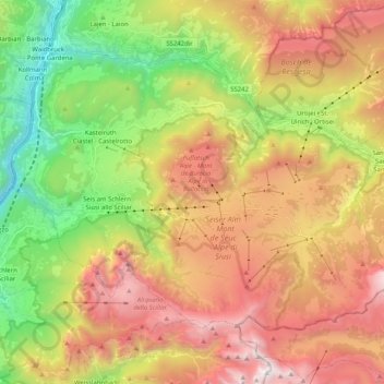
Nombre: Mapa topográfico Kastelruth - Castelrotto, altitud, relieve.
Altitud media: 1.561 m
Altitud mínima: 401 m
Altitud máxima: 2.863 m
Haz una donación
Otros mapas topográficos
Haga clic en un mapa para ver su topografía, su altitud y su relieve.
Sulden - Solda
Italy > Trentino – Alto Adige/Südtirol > South Tyrol > Stilfs - Stelvio
Altitud media: 2.232 m
Welsberg - Monguelfo
Italy > Trentino – Alto Adige/Südtirol > South Tyrol > Welsberg-Taisten - Monguelfo-Tesido
Altitud media: 1.289 m
Obereggen - San Floriano d'Ega
Italy > Trentino – Alto Adige/Südtirol > South Tyrol > Deutschnofen - Nova Ponente
Altitud media: 1.650 m
Gufidaun - Gudon
Italy > Trentino – Alto Adige/Südtirol > South Tyrol > Klausen - Chiusa
Altitud media: 860 m
Haz una donación
Secëda - Monte Seceda
Italy > Trentino – Alto Adige/Südtirol > South Tyrol > Santa Cristina Gherdëina - St. Christina in Gröden - Santa Cristina Valgardena
Monte Seceda is a 2,519-meter-elevation (8,264-foot) summit in the Odles Group of the Dolomites, a UNESCO World Heritage Site. Set in the Trentino-Alto Adige/Südtirol region, the peak is located four kilometers (2.5 miles) north of the village of Santa Cristina Gherdëina, and the peak is in Puez-Geisler…
Altitud media: 2.106 m
Flading - Vallettina
Italy > Trentino – Alto Adige/Südtirol > South Tyrol > Ratschings - Racines
Altitud media: 2.012 m
Funtanacia
Italy > Trentino – Alto Adige/Südtirol > South Tyrol > La Ila - Stern - La Villa
Altitud media: 1.787 m
Haz una donación
Schlern - Sciliar
Italy > Trentino – Alto Adige/Südtirol > South Tyrol > Völs am Schlern - Fiè allo Sciliar
Altitud media: 2.033 m
Grünsee - Lago Verde
Italy > Trentino – Alto Adige/Südtirol > South Tyrol > Ulten - Ultimo
Altitud media: 2.683 m
Haz una donación
Schmieden - Ferrara
Italy > Trentino – Alto Adige/Südtirol > South Tyrol > Prags - Braies
Altitud media: 1.426 m
Antlas
Italy > Trentino – Alto Adige/Südtirol > South Tyrol > Ritten - Renon > Atzwang - Campodazzo
Altitud media: 818 m
Nock
Italy > Trentino – Alto Adige/Südtirol > South Tyrol > Ratschings - Racines
Altitud media: 1.795 m
Gherdëina - Grödnertal - Val Gardena
Italy > Trentino – Alto Adige/Südtirol > South Tyrol > Urtijëi - St. Ulrich in Gröden - Ortisei
Altitud media: 1.607 m
Haz una donación
Tierseralpl - Alpe di Tires
Italy > Trentino – Alto Adige/Südtirol > South Tyrol > Tiers - Tires
Altitud media: 2.285 m
Haz una donación
Schluderbach - Carbonin
Italy > Trentino – Alto Adige/Südtirol > South Tyrol > Toblach - Dobbiaco
Altitud media: 1.776 m
Haz una donación
Langtauferer Tal - Vallelunga
Italy > Trentino – Alto Adige/Südtirol > South Tyrol > Graun - Curon Venosta
Altitud media: 2.513 m
St. Georg - San Giorgio di Eores
Italy > Trentino – Alto Adige/Südtirol > South Tyrol > Brixen - Bressanone
Altitud media: 1.476 m
St. Anton - Sant'Antonio
Italy > Trentino – Alto Adige/Südtirol > South Tyrol > St. Nikolaus - San Nicolò
Altitud media: 745 m
Haz una donación
Schneespitz - Cima della Neve
Italy > Trentino – Alto Adige/Südtirol > South Tyrol > Predoi
Altitud media: 2.497 m
Costadedoi
Italy > Trentino – Alto Adige/Südtirol > South Tyrol > San Ćiascian - St. Kassian - San Cassiano
Altitud media: 1.712 m
Obereggen - San Floriano d'Ega
Italy > Trentino – Alto Adige/Südtirol > South Tyrol > Deutschnofen - Nova Ponente
Altitud media: 1.650 m
Haz una donación
St. Magdalena - Santa Maddalena in Casies
Italy > Trentino – Alto Adige/Südtirol > South Tyrol > Gsies - Valle di Casies
Altitud media: 1.772 m
Croda del Becco - Sas dla Porta - Seekofel
Italy > Trentino – Alto Adige/Südtirol > South Tyrol > Prags - Braies
Altitud media: 2.186 m
Lengmoos - Longomoso
Italy > Trentino – Alto Adige/Südtirol > South Tyrol > Ritten - Renon > Klobenstein - Collalbo
Altitud media: 1.049 m
Haz una donación
Hoher Weißzint - Punta Bianca
Italy > Trentino – Alto Adige/Südtirol > South Tyrol > Mühlwald - Selva dei Molini
Altitud media: 2.905 m
Haz una donación
Turnerkamp - Cima di Campo
Italy > Trentino – Alto Adige/Südtirol > South Tyrol > Mühlwald - Selva dei Molini
Altitud media: 2.868 m
St. Anton - Sant'Antonio
Italy > Trentino – Alto Adige/Südtirol > South Tyrol > St. Nikolaus - San Nicolò
Altitud media: 745 m
Ortler - Ortles
Italy > Trentino – Alto Adige/Südtirol > South Tyrol > Stilfs - Stelvio
The Ortler was first climbed by Josef Pichler [de] ("Pseirer-Josele"), a chamois hunter from St. Leonhard in Passeier, and his companions Johann Leitner and Johann Klausner from Zell am Ziller on 27 September 1804. The ascent had been a request of Archduke Johann of Austria, who felt strongly that after the…
Altitud media: 3.175 m
Sulden - Solda
Italy > Trentino – Alto Adige/Südtirol > South Tyrol > Stilfs - Stelvio
Altitud media: 2.232 m
Haz una donación
Atzwang - Campodazzo
Italy > Trentino – Alto Adige/Südtirol > South Tyrol > Ritten - Renon
Altitud media: 786 m
Grube - Fossa
Italy > Trentino – Alto Adige/Südtirol > South Tyrol > Oberradein - Redagno di Sopra
Altitud media: 1.477 m
Haz una donación
Roen
Italy > Trentino – Alto Adige/Südtirol > South Tyrol > Tramin an der Weinstraße - Termeno sulla Strada del Vino
Altitud media: 1.740 m
Maring
Italy > Trentino – Alto Adige/Südtirol > South Tyrol > La Ila - Stern - La Villa
Altitud media: 1.727 m
Villa Nöia
Italy > Trentino – Alto Adige/Südtirol > South Tyrol > La Ila - Stern - La Villa
Altitud media: 1.632 m
Graun im Vinschgau - Curon Venosta
Italy > Trentino – Alto Adige/Südtirol > South Tyrol > Graun - Curon Venosta
Altitud media: 1.794 m
Haz una donación
Kühwiesenkopf - Monte Prà della Vacca
Italy > Trentino – Alto Adige/Südtirol > South Tyrol > Prags - Braies
Altitud media: 1.854 m
Mitterdorf - Caldaro di Mezzo
Italy > Trentino – Alto Adige/Südtirol > South Tyrol > St. Nikolaus - San Nicolò
Altitud media: 664 m
Seis am Schlern - Siusi allo Sciliar
Italy > Trentino – Alto Adige/Südtirol > South Tyrol > Kastelruth - Castelrotto
Altitud media: 1.211 m
Haz una donación
Reschen - Resia
Italy > Trentino – Alto Adige/Südtirol > South Tyrol > Graun - Curon Venosta
Altitud media: 1.814 m
St. Magdalena - Santa Maddalena in Casies
Italy > Trentino – Alto Adige/Südtirol > South Tyrol > Gsies - Valle di Casies
Altitud media: 1.772 m
Haz una donación
Telfen - Lanzin
Italy > Trentino – Alto Adige/Südtirol > South Tyrol > Kastelruth - Castelrotto > Kastelruth - Ciastel - Castelrotto
Altitud media: 1.035 m
Ortler - Ortles
Italy > Trentino – Alto Adige/Südtirol > South Tyrol > Stilfs - Stelvio
The Ortler was first climbed by Josef Pichler [de] ("Pseirer-Josele"), a chamois hunter from St. Leonhard in Passeier, and his companions Johann Leitner and Johann Klausner from Zell am Ziller on 27 September 1804. The ascent had been a request of Archduke Johann of Austria, who felt strongly that after the…
Altitud media: 3.175 m
Sulden - Solda
Italy > Trentino – Alto Adige/Südtirol > South Tyrol > Stilfs - Stelvio
Altitud media: 2.232 m
Hintere Schwärze
Italy > Trentino – Alto Adige/Südtirol > South Tyrol > Schnals - Senales
Altitud media: 3.152 m
Haz una donación
Kampenn - Campegno
Italy > Trentino – Alto Adige/Südtirol > South Tyrol > Bolzano > Rentsch - Rencio
Altitud media: 670 m
Seis am Schlern - Siusi allo Sciliar
Italy > Trentino – Alto Adige/Südtirol > South Tyrol > Kastelruth - Castelrotto
Altitud media: 1.211 m
Haz una donación
Dörfl
Italy > Trentino – Alto Adige/Südtirol > South Tyrol > Gsies - Valle di Casies > St. Magdalena - Santa Maddalena in Casies
Altitud media: 1.770 m
Steinhaus - Cadipietra
Italy > Trentino – Alto Adige/Südtirol > South Tyrol > Ahrntal - Valle Aurina
Altitud media: 1.491 m
Haz una donación
Weissenbach - Rio Bianco
Italy > Trentino – Alto Adige/Südtirol > South Tyrol > Sarntal - Sarentino
Altitud media: 1.718 m
Gherdëina - Grödnertal - Val Gardena
Italy > Trentino – Alto Adige/Südtirol > South Tyrol > Urtijëi - St. Ulrich in Gröden - Ortisei
Altitud media: 1.588 m
Saslonch - Langkofel - Sassolungo
Italy > Trentino – Alto Adige/Südtirol > South Tyrol > Sëlva - Wolkenstein - Selva di Val Gardena
Altitud media: 2.320 m
Haz una donación
Calfosch - Kolfuschg - Colfosco
Italy > Trentino – Alto Adige/Südtirol > South Tyrol
Altitud media: 1.931 m