
Haz una donación
Mapa topográfico Kreuzberg
Haga clic en el mapa para ver la altitud.
Haz una donación
Kreuzberg
In contrast to many other areas of Berlin, which were villages before their integration into Berlin, Kreuzberg has a rather short history. It was formed on 1 October 1920 by the Greater Berlin Act, which provided for the incorporation of suburbs and the reorganisation of Berlin into twenty boroughs. The eastern Friedrichsvorstadt, the southern Friedrichstadt, the western and southern Luisenstadt, and the Tempelhofer Vorstadt were merged into the new sixth borough of Berlin, first named Hallesches Tor. On 27 September 1921, the borough assembly of Hallesches Tor decided to rename the borough after the homonymous hill. Kreuzberg, literally meaning 'cross hill', is the point of the highest elevation in the Kreuzberg locality, which is 66 m (217 ft) above sea level. The hill is traditionally a place for weekend trips. It received its name from the 1821 Prussian National Monument for the Liberation Wars by Karl Friedrich Schinkel within the Viktoriapark, built in commemoration of the Napoleonic Wars. Except for its northernmost part—the quarter Friedrichstadt (established at the end of the 17th century)—today's Kreuzberg was a very rural place until well into the 19th century.
Haz una donación
Acerca de este mapa
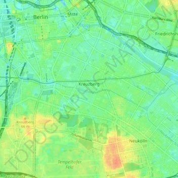
Nombre: Mapa topográfico Kreuzberg, altitud, relieve.
Lugar: Kreuzberg, Friedrichshain-Kreuzberg, Berlin, Germany (52.48279 13.36823 52.50938 13.45293)
Altitud media: 43 m
Altitud mínima: 29 m
Altitud máxima: 67 m
Haz una donación
Otros mapas topográficos
Haga clic en un mapa para ver su topografía, su altitud y su relieve.
Teufelsberg
Teufelsberg was originally thought to be 115 metres (377 ft) high, which placed it at the same elevation as Großer Müggelberg (the summit of Müggelberge), and was the highest point in West Berlin. New measurements show that Teufelsberg is actually 120.1 metres (394 ft) high, making it higher than Großer…
Altitud media: 54 m
Viktoriapark
On the occasion of the elevation of the monument ideas appeared to lay out a park around it. Two years later the design of a park was put out to tender. Hermann Mächtig (*1837-1909*), since 1877 Berlin's city garden director, handed in a design, already using the name Victoria Park, in honour of Princess…
Altitud media: 45 m
Haz una donación