
Mapa topográfico Camarillo
Mapa interactivo
Haga clic en el mapa para ver la altitud.
Acerca de este mapa
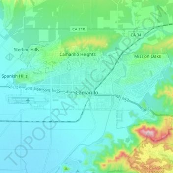
Nombre: Mapa topográfico Camarillo, altitud, relieve.
Altitud media: 90 m
Altitud mínima: 6 m
Altitud máxima: 545 m
In the mid-1950s, the Ventura Freeway, which bisects the town, was completed from Los Angeles to points north, making it an easy one-hour trip to Camarillo. The freeway was originally planned to follow the path of Potrero Road, south of Camarillo, which would have completely by-passed the soon-to-be city. However, after much debate, city officials persuaded Caltrans to lay the freeway parallel to Ventura Boulevard, creating the infamously steep descent from the Santa Monica Mountains, known as the Conejo Grade. The grade is about 2.7 miles (4.3 km) and posted as a 7% grade—which translates as about one thousand feet of elevation change in less than three miles (70 meters per kilometer). There is a California Highway Patrol brake inspection station at the top of the grade and a stop is mandatory for all 18-wheel trucks. The completion of the freeway facilitated the growth that followed. In 1962, the population was 7,500 and 3M began construction for the Mincom and Magnetic Tape Divisions, which would ultimately employ 900 people, becoming the largest local employer. That plant briefly housed a factory for 3M spinoff Imation before being closed in 2008.
Otros mapas topográficos
Haga clic en un mapa para ver su topografía, su altitud y su relieve.
Ojai
United States > California > Ventura County
Ojai, Ventura County, California, 93023, United States
Altitud media: 289 m
Oak View
United States > California > Ventura County
Oak View, Ventura County, CAL Fire Southern Region, California, 93022, United States
Altitud media: 184 m
Jasmine Glen Estates
United States > California > Ventura County > Simi Valley
Jasmine Glen Estates, Simi Valley, Ventura County, CAL Fire Southern Region, California, 90363, United States
Altitud media: 331 m
San Buenaventura (Ventura)
United States > California > Ventura County
San Buenaventura (Ventura), Ventura County, CAL Fire Southern Region, California, United States
Altitud media: 158 m
SSFL South Buffer
United States > California > Ventura County
SSFL South Buffer, Ventura County, CAL Fire Contract Counties, California, United States
Altitud media: 504 m
Port Hueneme
United States > California > Ventura County
Port Hueneme, Ventura County, CAL Fire Southern Region, California, United States
Altitud media: 7 m
Lake Sherwood
United States > California > Ventura County
Lake Sherwood, Ventura County, California, United States
Altitud media: 332 m
Newbury Park
United States > California > Ventura County > Thousand Oaks > Newbury Park
Newbury Park, Thousand Oaks, Ventura County, California, 91320, United States
Altitud media: 262 m
Somis
United States > California > Ventura County
Somis, Ventura County, CAL Fire Southern Region, California, 93066, United States
Altitud media: 112 m
Simi Valley
United States > California > Ventura County > Simi Valley
Simi Valley, Ventura County, California, 93063-2364, United States
Altitud media: 379 m
Simi Valley
United States > California > Ventura County
Simi Valley, Ventura County, California, United States
Altitud media: 405 m
Thousand Oaks
United States > California > Ventura County
Thousand Oaks, Ventura County, California, United States
Altitud media: 333 m
Strathearn
United States > California > Ventura County > Simi Valley
Strathearn, Simi Valley, Ventura County, CAL Fire Southern Region, California, 93065, United States
Altitud media: 261 m
Santa Paula
United States > California > Ventura County
Santa Paula, Ventura County, CAL Fire Southern Region, California, United States
Altitud media: 148 m
Greenwich Village
United States > California > Ventura County > Thousand Oaks > Greenwich Village
Greenwich Village, Thousand Oaks, Ventura County, California, 91360-4401, United States
Altitud media: 275 m
Casitas Springs
United States > California > Ventura County > Ventura > Casitas Springs
Casitas Springs, Ventura, Ventura County, California, 93022, United States
Altitud media: 182 m
Johnson Creek Park
United States > California > Ventura County > Oxnard > Pleasant Valley Mobile Home Park
Johnson Creek Park, Pleasant Valley Mobile Home Park, Oxnard, Ventura County, California, United States
Altitud media: 10 m
Oxnard
United States > California > Ventura County
Oxnard, Ventura County, California, United States
Altitud media: 16 m
Anacapa Island
United States > California > Ventura County
Anacapa Island, Ventura County, California, United States
Altitud media: 4 m
Thousand Oaks
United States > California > Ventura County > Thousand Oaks
Thousand Oaks, Ventura County, California, United States
Altitud media: 303 m
Ventura
United States > California > Ventura County
Ventura, Ventura County, CAL Fire Southern Region, California, United States
Altitud media: 120 m