
Mapa topográfico Stroud
Haga clic en el mapa para ver la altitud.
Acerca de este mapa
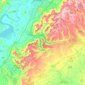
Nombre: Mapa topográfico Stroud, altitud, relieve.
Lugar: Stroud, Gloucestershire, England, United Kingdom (51.58984 -2.54081 51.85046 -2.06871)
Altitud media: 113 m
Altitud mínima: 0 m
Altitud máxima: 302 m
Otros mapas topográficos
Haga clic en un mapa para ver su topografía, su altitud y su relieve.
Jubilee Playing Field & Athletics Track
United Kingdom > England > Gloucestershire > Stroud > Cam > Draycott
Altitud media: 45 m
Duntisbourne Abbots
United Kingdom > England > Gloucestershire > Cotswold District
Altitud media: 204 m
Highbury
United Kingdom > England > Gloucestershire > Forest of Dean > Lydney > Allaston
Altitud media: 65 m
Grange Village
United Kingdom > England > Gloucestershire > Forest of Dean > Littledean
Altitud media: 98 m
Calcot
United Kingdom > England > Gloucestershire > Cotswold District > Coln Rogers
Altitud media: 151 m
Saunders Green
United Kingdom > England > Gloucestershire > Forest of Dean > Whitecroft
Altitud media: 111 m
Bakers Hill
United Kingdom > England > Gloucestershire > Forest of Dean > Broadwell
Altitud media: 195 m
Lydney Hub
United Kingdom > England > Gloucestershire > Forest of Dean > Lydney > Allaston > Tutnalls
Altitud media: 42 m
Caudle Green
United Kingdom > England > Gloucestershire > Cotswold District > Brimpsfield
Altitud media: 234 m
Newent Woods
United Kingdom > England > Gloucestershire > Forest of Dean > May Hill
Altitud media: 157 m
Bourton-on-the-Hill
United Kingdom > England > Gloucestershire > Cotswold District
Altitud media: 196 m
Hidcote Bartrim
United Kingdom > England > Gloucestershire > Cotswold District > Ebrington
Altitud media: 148 m
The Pludds
United Kingdom > England > Gloucestershire > Forest of Dean > Ruardean
Altitud media: 170 m
Joys Green
United Kingdom > England > Gloucestershire > Forest of Dean > Upper Lydbrook
Altitud media: 142 m
Bushley Muzzard, Brimpsfield
United Kingdom > England > Gloucestershire > Cotswold District > Nettleton > Watercombe
Altitud media: 261 m
Westbury-on-Severn
United Kingdom > England > Gloucestershire > Forest of Dean District
Altitud media: 17 m
Wigpool Green
United Kingdom > England > Gloucestershire > Forest of Dean District > Puddlebrook > Wigpool Green
Altitud media: 173 m
Dursley Cross
United Kingdom > England > Gloucestershire > Forest of Dean District > May Hill > Dursley Cross
Altitud media: 126 m
Bishop's Cleeve
United Kingdom > England > Gloucestershire > Tewkesbury > Gotherington
Altitud media: 51 m
Plump Hill
United Kingdom > England > Gloucestershire > Forest of Dean > Abenhall > Plump Hill
Altitud media: 195 m
Crumpmeadow Inclosure
United Kingdom > England > Gloucestershire > Forest of Dean > Cinderford
Altitud media: 167 m