
Mapa topográfico Piétrain
Mapa interactivo
Haga clic en el mapa para ver la altitud.
Acerca de este mapa
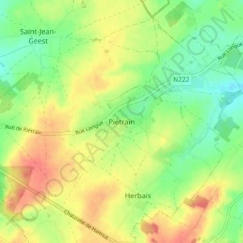
Nombre: Mapa topográfico Piétrain, altitud, relieve.
Lugar: Piétrain, Nivelles, Brabant wallon, Wallonie, 3321, Belgique (50.70550 4.89755 50.74550 4.93755)
Altitud media: 91 m
Altitud mínima: 64 m
Altitud máxima: 120 m
Otros mapas topográficos
Haga clic en un mapa para ver su topografía, su altitud y su relieve.
Grez-Doiceau
Belgique > Brabant wallon > Nivelles
Grez-Doiceau, Nivelles, Brabant wallon, Wallonie, 1390, Belgique
Altitud media: 81 m
Céroux-Mousty
Belgique > Brabant wallon > Nivelles > Ottignies-Louvain-la-Neuve
Céroux-Mousty, Ottignies-Louvain-la-Neuve, Nivelles, Brabant wallon, Wallonie, 1341, Belgique
Altitud media: 109 m
Waterloo
Belgique > Brabant wallon > Nivelles > Waterloo
Waterloo, Nivelles, Brabant wallon, Wallonie, 1410, Belgique
Altitud media: 110 m
Nivelles
Belgique > Brabant wallon > Nivelles
Nivelles, Brabant wallon, Wallonie, Belgique
Altitud media: 132 m
Sart-Dames-Avelines
Belgique > Brabant wallon > Nivelles > Villers-la-Ville
Sart-Dames-Avelines, Villers-la-Ville, Nivelles, Brabant wallon, Wallonie, Belgique
Altitud media: 147 m
Baulers
Belgique > Brabant wallon > Nivelles > Nivelles
Baulers, Nivelles, Brabant wallon, Wallonie, 1401, Belgique
Altitud media: 138 m
Limal
Belgique > Brabant wallon > Nivelles > Wavre
Limal, Wavre, Nivelles, Brabant wallon, Wallonie, Belgique
Altitud media: 88 m
Wavre
Belgique > Brabant wallon > Nivelles
Wavre, Nivelles, Brabant wallon, Wallonie, Belgique
Altitud media: 80 m
Rofessart
Belgique > Brabant wallon > Nivelles > Ottignies-Louvain-la-Neuve
Rofessart, Limelette, Ottignies-Louvain-la-Neuve, Nivelles, Brabant wallon, Wallonie, 1330, Belgique
Altitud media: 98 m
Lasne
Belgique > Brabant wallon > Nivelles
Lasne, Nivelles, Brabant wallon, Wallonie, 1380, Belgique
Altitud media: 107 m