
Gracias por apoyar a este sitio ❤️
Haz una donación
Haz una donación
Mapa topográfico Bakersfield
Haga clic en el mapa para ver la altitud.
Gracias por apoyar a este sitio ❤️
Haz una donación
Haz una donación
Bakersfield
Most of Bakersfield's major streets are six-lane divided roads with bike lanes, with most streets in the city having proper lane signage for bicycle traffic but little to no protection from vehicle traffic. Despite the city's relatively flat topography and grid-like street system, only around 2,782 bike commuters exist, as estimated in 2013, around 0.7% of its total population then.
Gracias por apoyar a este sitio ❤️
Haz una donación
Haz una donación
Acerca de este mapa
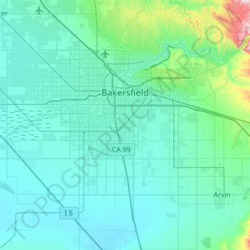
Nombre: Mapa topográfico Bakersfield, altitud, relieve.
Lugar: Bakersfield, Kern County, California, United States (35.19398 -119.26503 35.44730 -118.77234)
Altitud media: 157 m
Altitud mínima: 81 m
Altitud máxima: 915 m
Gracias por apoyar a este sitio ❤️
Haz una donación
Haz una donación
Otros mapas topográficos
Haga clic en un mapa para ver su topografía, su altitud y su relieve.