Mapa topográfico Leyte
Haga clic en el mapa para ver la altitud.
Acerca de este mapa
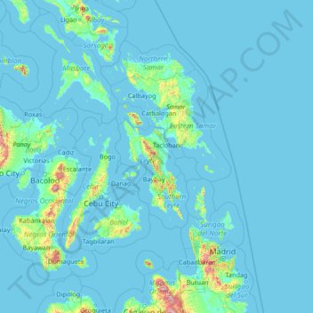
Nombre: Mapa topográfico Leyte, altitud, relieve.
Lugar: Leyte, Eastern Visayas, Philippines (8.35000 122.25000 13.55000 127.45000)
Altitud media: 54 m
Altitud mínima: -1 m
Altitud máxima: 2.354 m
Otros mapas topográficos
Haga clic en un mapa para ver su topografía, su altitud y su relieve.

Metro Manila
The Coastal Margin or Lowland is a flat and low plain that faces Manila Bay. Located here is Manila, Navotas, parts of Malabon, and the western part and reclaimed areas of Pasay and Parañaque, where the ground elevation ranges from zero meters on Manila Bay to five meters at the west side of the cities of…
Altitud media: 43 m
Metro Manila
The Coastal Margin or Lowland is a flat and low plain that faces Manila Bay. Located here is Manila, Navotas, parts of Malabon, and the western part and reclaimed areas of Pasay and Parañaque, where the ground elevation ranges from zero meters on Manila Bay to five meters at the west side of the cities of…
Altitud media: 43 m
Cavite
Another theory proposes that the name is a Hispanicized form of kabit, Tagalog for "joined", "connected", or "attached", referring to the peninsula's topographical relation to the mainland. Edmund Roberts, in his 1821 memoir, stated that the "natives" called it Caveit due to the "crooked point of land…
Altitud media: 88 m
Batangas
Batangas is a combination of plains and mountains, including one of the world's smallest volcanoes, Mt. Taal, with an elevation of 600 metres (2,000 ft), located in the middle of the Taal Lake. Other important peaks are Mount Macolod with an elevation of 830 metres (2,720 ft), Mt. Banoy with 960 metres (3,150…
Altitud media: 126 m
Quezon City
In order to make Quezon's dream a reality and to mobilize funds for the land purchase, the People's Homesite Corporation (PHC) was created on October 14, 1938, as a subsidiary of NDC, with an initial capital of ₱2 million. Roces was the chairman of the Board of PHC, and they immediately acquired the vast…
Altitud media: 39 m
Baguio
In 1903, Filipinos, Japanese and Chinese workers were hired to build Kennon Road, the first road directly connecting Baguio with the lowlands of La Union and Pangasinan. Before this, the only road to Benguet was Naguilian Road, and it was largely a horse trail at higher elevations. Camp John Hay was…
Altitud media: 1.371 m

Bataan
Bataan is divided by two mountain groups of volcanic origins. The northern side is composed of the Mount Natib (elevation 1,253 metres (4,111 ft)), Mount Sta. Rosa and Mount Silangan. The southern group is composed of Mount Mariveles, Mount Samat, and Mount Cuyapo. A narrow pass separates these two mountain…
Altitud media: 70 m


Antipolo
Its higher elevation than that of Metro Manila affords it a scenic view of the metropolitan area, especially at night. Its locally grown mangoes and cashews are popular among tourists, as well as suman – a local delicacy made out of glutinous rice. The Hinulugang Taktak National Park, which was once a…
Altitud media: 157 m
Lipa
At the celebration of the elevation of Lipa to a city in January 1888, José Rizal was invited by Dr. Jose Lozada, Catalino Dimayuga and the brothers Celestino and Simeon Luz but Rizal responded only with his Hymno Al Trabajo which he dedicated to the zeal and industry of the Lipeños.
Altitud media: 208 m


Mandaluyong
Another claims that the Spaniards named the place based on the report of a navigator named Acapulco, who saw the rolling hills frequently being lashed at by daluyong (“big waves from the sea”). This seems to confirm traditional pre-Hispanic stories that giant waves from the sea would meet the adjoining…
Altitud media: 17 m

Ilocos Sur
Ilocos Sur occupies the central section of the Ilocos Region in northern Luzon. It is bordered by Ilocos Norte to the north, Abra to the northeast, Mountain Province to the east, Benguet to the southeast, La Union to the south, and the South China Sea to the west. Its area of 2,596.00 square kilometres…
Altitud media: 468 m


Laguna
Laguna is home to 24 mountains, most of which are inactive volcanoes. The highest peak in Laguna is Mt. Banahaw, with an elevation of 2,170 m (7,120 ft). Banahaw, unlike most other volcanoes in Laguna, is an active complex stratovolcano, which last erupted in 1843. Banahaw is located in the boundary of Laguna…
Altitud media: 183 m


Biliran
The main volcanic island of Biliran features mountainous interiors with very narrow coastal areas. Only the municipalities of Naval and Caibiran have wide plains extending about 7 km (4.3 mi) from the coast suitable for agriculture. Mount Suiro, an inactive volcano, is the highest point on Biliran Island with…
Altitud media: 54 m

Cagayan de Oro
Cagayan de Oro, located along the north-central coast of Mindanao, Philippines, encompasses a diverse topography that significantly influences its terrain. The city spans approximately 488.86 square kilometers (188.75 square miles), featuring a 25-kilometer (16 miles) coastline along Macajalar Bay. The…
Altitud media: 224 m


Dinagat Islands
Dinagat Islands is a young island-province at the northern tip of Mindanao. Many describe Dinagat Islands as a hidden gem of the Caraga Region XIII. The Islands are enriched with great bio-diversity, abundant natural wonders and rich resources. Dinagat Islands has a multitude of fascinating white sandy beaches…
Altitud media: 24 m




Bukidnon
Situated within Bukidnon is Mount Dulang-dulang, the 2nd highest mountain in the country, with an elevation of 2,938 metres (9,639 ft) located in the Kitanglad Mountain Range. Mount Kitanglad (2,899 m), Mount Kalatungan (2,860 m), Mount Maagnaw (2,742 m), Mount Lumuluyaw (2,612 m), and Mount Tuminungan (2,400…
Altitud media: 686 m
Isabela
The province is divided into three physiographic areas. The eastern area, straddled by the Sierra Madre mountain range, is rugged and thickly forested. A substantial portion is uncharted. These unexplored hinterlands are home to a rich variety of flora and fauna, and some are under government reservations. It…
Altitud media: 227 m


Romblon
The province has a total land area of approximately 1,533.45 square kilometres (592 sq mi) representing about 5.3 percent of the total land area of Region IV-B Mimaropa. It is generally mountainous with about 40 percent of its land area having an inclination of more than 50 percent. Only four percent of the…
Altitud media: 16 m
Muntinlupa
There are three plausible origins of the name of the city: First, is its association with the thin topsoil in the area; second, residents, purportedly replying to a question by Spaniards in the 16th century what the name of their place was, said “Monte sa Lupa”—apparently mistaking the question for what…
Altitud media: 22 m


Basilan
Basilan National Park is at the eastern portion of the remaining public forest between the city of Isabela and the municipalities of Lamitan, Tipo-Tipo and Sumisip. The park has an elevation of 971 metres (3,186 ft) above sea level, and the tallest peak, Puno Mahaji or Basilan Peak, dominates the park's…
Altitud media: 32 m

Bacolod
Bacólod (English: Bacolod), is derived from bakólod (Old Spelling: bacólod), the Old Hiligaynon (Old Ilonggo) (Old Spelling: Ylongo and Ilongo) word for a "hill, turtle, mound, rise, hillock, down, any small eminence or elevation", since the resettlement was founded on a stony, hilly area, now the barangay…
Altitud media: 54 m


Dasmariñas
Dasmariñas is partly lowland and partly hilly. The Poblacion itself is elevated. From an elevation of 80 meters (260 ft) at the Poblacion, the land rises to 250 meters (820 ft) towards Silang. Generally, land near rivers and creeks are rugged. Dasmariñas is outside the typhoon belt and has no fault line…
Altitud media: 126 m


Masbate
The general surface configuration of the province ranges from slightly undulating to rolling and from hilly to mountainous. In each island, the rugged topography is concentrated in the northeastern portion and gradually recedes to blunt hills and rolling areas in the south, southeast, and southwest.
Altitud media: 28 m
Mindanao
In the eastern portion of the island, from Bilas Point in Surigao del Norte to Cape San Agustin in Davao Oriental, is a range of complex mountains, called the Eastern Pacific Cordillera, known in their northern portion as the Diwata Mountains. This range is low and rolling in its central portion. A proposed…
Altitud media: 149 m

Negros Oriental
The province's topography is characterized by low, grooved mountain ranges of which some lie close to the shoreline. At the southern end of the province is Mount Talinis, also known as Cuernos de Negros ("Horns of Negros"), which is a dormant complex volcano which rises to a height of 2,000 metres (6,600 ft).…
Altitud media: 116 m

Capiz
Capiz covers a total area of 2,594.64 square kilometres (1,001.80 sq mi) occupying the northeastern portion of Panay Island, and is one of the five provinces that compose the Western Visayas region. Mount Nangtud, is the highest mountain in Capiz with an elevation of 6,804 ft (2,074 m) located in the…
Altitud media: 123 m

Valenzuela
The highest elevation point is 38 metres (125 ft) above sea level. Having a surface gradient of 0.55% and a gentle slope, hilly landscape is located in the industrial section of the city in Canumay. The average elevation point is 2 metres (6.6 ft) above sea level.
Altitud media: 6 m


Zamboanga Peninsula
Pagadian is known as the "Little Hong Kong of the South" because of its topographical feature that is reminiscent of Hong Kong. It also has an affluent Chinese community that officially celebrates the Chinese Lunar New Year.
Altitud media: 81 m




Second Thomas Shoal
On July 12, 2016, the UNCLOS tribunal at the Permanent Court of Arbitration concluded that Second Thomas Shoal is, or in its natural condition was, exposed at low tide and submerged at high tide and, accordingly, has low-tide elevations that do not generate an entitlement to a territorial sea, exclusive…
Altitud media: 0 m




Southern Leyte
Along with other mountain forms in the province, Mount Nacolod in Hinunangan town has the highest peak with an elevation of 948 metres (3,110 ft) above sea level. Young volcanic rocks are discovered in the terrain areas, which cover the top of the southern mountain ranges of Mount Cabalian in the Pacific Area…
Altitud media: 66 m


Aklan
Mount Nausang, is formerly the highest peak in Aklan, standing at 5,190 ft (1,580 m), the discovery of Mount Timbaban is much higher, with an elevation of 5,830.1 ft (1,777.0 m) above sea level, Mount Timbaban is not considered as independent mountain, it is still part of Mount Madja-as sub-summit with only…
Altitud media: 96 m

Siquijor
The island lies about 19 kilometres (12 mi) east of the nearest point on southern Negros, 25 kilometres (16 mi) southeast of Cebu, 30 kilometres (19 mi) southwest of Bohol, and 45 kilometres (28 mi) north of Zamboanga del Norte in Mindanao. It is predominantly hilly and in many places the hills reach the sea,…
Altitud media: 17 m

Ilocos Region
The southern parts of the region were severely hit by the 1990 Luzon earthquake. Five municipalities in La Union were affected: Agoo, Aringay, Caba, Santo Tomas, and Tubao with a combined population of 132,208. Many buildings, including the Agoo Municipal hall, the Museo de Iloko, the parish church of Aringay,…
Altitud media: 219 m

Benguet
The province suffers from crop damage resulting from seasonal frost during the cold months of December to March, especially in high-altitude towns such as Atok, Buguias, Mankayan and Kibungan. In February 2007, Benguet suffered crop damage due to temperatures reaching as low as 7 °C (45 °F).
Altitud media: 908 m