
Mapa topográfico Hart
Mapa interactivo
Haga clic en el mapa para ver la altitud.
Acerca de este mapa
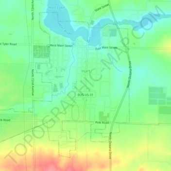
Nombre: Mapa topográfico Hart, altitud, relieve.
Lugar: Hart, Oceana County, Michigan, United States (43.68149 -86.39769 43.70963 -86.35223)
Altitud media: 215 m
Altitud mínima: 186 m
Altitud máxima: 263 m
Otros mapas topográficos
Haga clic en un mapa para ver su topografía, su altitud y su relieve.
Rothbury
United States > Michigan > Oceana County
Rothbury, Grant Township, Oceana County, Michigan, United States
Altitud media: 210 m
Grant Township
United States > Michigan > Oceana County
Grant Township, Oceana County, Michigan, 49452, United States
Altitud media: 219 m
Greenwood Township
United States > Michigan > Oceana County
Greenwood Township, Oceana County, Michigan, United States
Altitud media: 220 m
Golden Township
United States > Michigan > Oceana County
Golden Township, Oceana County, Michigan, 49436, United States
Altitud media: 211 m
Shelby Township
United States > Michigan > Oceana County
Shelby Township, Oceana County, Michigan, 49455, United States
Altitud media: 261 m