
Mapa topográfico Pilot Butte
Mapa interactivo
Haga clic en el mapa para ver la altitud.
Acerca de este mapa
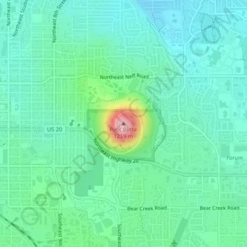
Nombre: Mapa topográfico Pilot Butte, altitud, relieve.
Altitud media: 1.113 m
Altitud mínima: 1.071 m
Altitud máxima: 1.260 m
The 114.22-acre (46.22-hectare) Pilot Butte State Scenic Viewpoint, presented as a gift to the State of Oregon in 1928, is a Bend icon. Pilot Butte itself is a popular hiking destination with two trails to the summit, each gaining about 490 feet (150 m) in elevation. There is also a 1.8-mile (2.9 km) trail around the base of the butte. A scenic road also winds up and around the cone. In 2018, the park was the most visited Oregon state park east of the Cascade Mountains. From the top, the entire city of Bend is visible, as well as several major Cascade peaks. Most prominent are the Three Sisters, Broken Top, and Mount Bachelor, which are located about 20 miles (32 km) to the west. The City of Bend launches Fourth of July fireworks from Pilot Butte each year.
Otros mapas topográficos
Haga clic en un mapa para ver su topografía, su altitud y su relieve.
Archie Briggs Canyon Natural Area
United States > Oregon > Deschutes County > Bend
Archie Briggs Canyon Natural Area, Northwest Falcon Ridge, Bend, Deschutes County, Oregon, 97703, United States
Altitud media: 1.115 m