
Haz una donación
Mapa topográfico Tagliamento
Haga clic en el mapa para ver la altitud.
Haz una donación
Tagliamento
The source is at an elevation of 1,195 metres (3,921 ft) in the Veneto region (Lorenzago di Cadore) in the Province of Belluno near the border with the Province of Udine, north-west of Forni di Sopra close to the Mauria Pass. Initially, the river's course is in a west to east direction, parallel to the Carnic Alps range. The first tributary of note is the Lumiei, which enters the Tagliamento from the left at a distance of 26 kilometres (16 mi) from the source.
Haz una donación
Acerca de este mapa
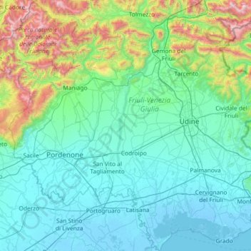
Nombre: Mapa topográfico Tagliamento, altitud, relieve.
Lugar: Tagliamento, Friuli – Venezia Giulia, Italy (45.64400 12.52147 46.44997 13.13929)
Altitud media: 390 m
Altitud mínima: -6 m
Altitud máxima: 2.706 m
Haz una donación
Otros mapas topográficos
Haga clic en un mapa para ver su topografía, su altitud y su relieve.
Haz una donación
Albana / Ibána / Albane
Italy > Friuli – Venezia Giulia > Udine / Udin / Videm > Prepotto / Prapotno / Prepot
Altitud media: 175 m
Tribil Superiore / Gorenji Tarbij
Italy > Friuli – Venezia Giulia > Udine > Stregna
Altitud media: 500 m
Haz una donación
Erto / Nert
Italy > Friuli – Venezia Giulia > Pordenone / Pordenon > Erto e Casso
Altitud media: 1.112 m
Haz una donación
Zegla / Ceglo
Italy > Friuli – Venezia Giulia > Gorizia / Gurize / Gorica > Cormons / Cormòns / Krmin
Altitud media: 85 m
Haz una donación
Montemaggiore / Brezje
Italy > Friuli – Venezia Giulia > Udine / Udin / Videm > Taipana
Altitud media: 817 m
Timau / Tischlbong
Italy > Friuli – Venezia Giulia > Udine > Paluzza / Paluce / Palutsch
Altitud media: 1.307 m
Haz una donación
Haz una donación
Haz una donación
Bannia / Banìe
Italy > Friuli – Venezia Giulia > Pordenone / Pordenon > Fiume Veneto
Altitud media: 21 m
Monte Tamai
Italy > Friuli – Venezia Giulia > Udine / Udin / Videm > Ovaro / Davâr
Altitud media: 1.588 m
Haz una donación
Sauris di Sopra / Plozn / Sauris Disore
Italy > Friuli – Venezia Giulia > Udine
Altitud media: 1.469 m
Monte Lubia / Ljubija
Italy > Friuli – Venezia Giulia > Udine / Udin / Videm > Pulfero
Altitud media: 795 m
Haz una donación
Sandrine
Italy > Friuli – Venezia Giulia > Udine / Udin / Videm > Artegna / Dartigne > Borc dal Steli
Altitud media: 263 m