
Mapa topográfico Tecopa
Mapa interactivo
Haga clic en el mapa para ver la altitud.
Acerca de este mapa
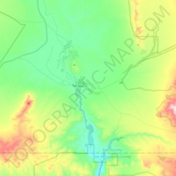
Nombre: Mapa topográfico Tecopa, altitud, relieve.
Altitud media: 508 m
Altitud mínima: 308 m
Altitud máxima: 926 m
Tecopa (formerly Brownsville) is a census-designated place (CDP) in the Mojave Desert, in Inyo County, California, United States. Tecopa is located 9 miles (14 km) south-southeast of Shoshone, at an elevation of 1,339 feet (408 m). The population was 150 at the 2010 census, up from 99 at the 2000 census.
Otros mapas topográficos
Haga clic en un mapa para ver su topografía, su altitud y su relieve.
Grimshaw Lake
United States > California > CAL Fire San Bernardino Unit > Tecopa
Grimshaw Lake, Tecopa, CAL Fire San Bernardino Unit, CAL Fire Southern Region, California, United States
Altitud media: 425 m