
Mapa topográfico Arciprestazgo de Alcalá Sur
Mapa interactivo
Haga clic en el mapa para ver la altitud.
Acerca de este mapa
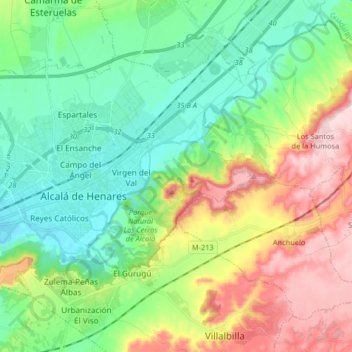
Nombre: Mapa topográfico Arciprestazgo de Alcalá Sur, altitud, relieve.
Altitud media: 685 m
Altitud mínima: 576 m
Altitud máxima: 899 m
Standing at an average altitude of 654 m, and occupying some 88 km2; the city was for a long time contained in between the Henares to the South and the Madrid-Barcelona railway to the North. However, the increasing population brought on the sprawl of the urbanised area to the area located in between the railway and the A-2 motorway and beyond.