
Mapa topográfico Cellarhead
Haga clic en el mapa para ver la altitud.
Acerca de este mapa
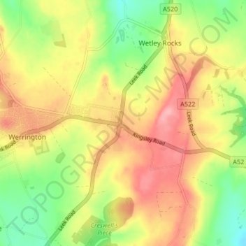
Nombre: Mapa topográfico Cellarhead, altitud, relieve.
Altitud media: 240 m
Altitud mínima: 185 m
Altitud máxima: 290 m
Otros mapas topográficos
Haga clic en un mapa para ver su topografía, su altitud y su relieve.
Stepping Stones
United Kingdom > England > Staffordshire > Staffordshire Moorlands
Altitud media: 224 m
Biddulph Grange Country Park
United Kingdom > England > Staffordshire > Staffordshire Moorlands > Biddulph > Biddulph Moor
Altitud media: 229 m
Rudyard Lake
United Kingdom > England > Staffordshire > Staffordshire Moorlands > Rudyard > Horton
Altitud media: 205 m
Hales Hall Pool
United Kingdom > England > Staffordshire > Staffordshire Moorlands > Cheadle
Altitud media: 182 m
Draycott in the Moors
United Kingdom > England > Staffordshire > Staffordshire Moorlands
Altitud media: 177 m
Ladderedge Country Park
United Kingdom > England > Staffordshire > Staffordshire Moorlands > Leek
Altitud media: 176 m
Checkley
United Kingdom > England > Staffordshire > Staffordshire Moorlands > Checkley
Altitud media: 166 m
Dimmingsdale Valley
United Kingdom > England > Staffordshire > Staffordshire Moorlands > Alton
Altitud media: 177 m
Alton Castle
United Kingdom > England > Staffordshire > Staffordshire Moorlands > Alton
Altitud media: 154 m
Consall
United Kingdom > England > Staffordshire > Staffordshire Moorlands > Consall
Altitud media: 216 m
Endon Basin
United Kingdom > England > Staffordshire > Staffordshire Moorlands > Endon
Altitud media: 179 m