
Gracias por apoyar a este sitio ❤️
Haz una donación
Haz una donación
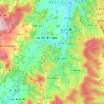
Mapa topográfico Reichelsheim (Odenwald)
Haga clic en el mapa para ver la altitud.
Gracias por apoyar a este sitio ❤️
Haz una donación
Haz una donación
Reichelsheim (Odenwald)
Reichelsheim lies in the middle Odenwald at elevations between 200 and 538 m in the middle of the Geo-Naturpark Bergstraße-Odenwald.
Gracias por apoyar a este sitio ❤️
Haz una donación
Haz una donación
Acerca de este mapa
Nombre: Mapa topográfico Reichelsheim (Odenwald), altitud, relieve.
Lugar: Reichelsheim (Odenwald), Odenwaldkreis, Hesse, 64385, Germany (49.65582 8.78444 49.74506 8.92912)
Altitud media: 335 m
Altitud mínima: 179 m
Altitud máxima: 593 m
Gracias por apoyar a este sitio ❤️
Haz una donación
Haz una donación