
Gracias por apoyar a este sitio ❤️
Haz una donación
Haz una donación
Mapa topográfico Villa Minozzo
Haga clic en el mapa para ver la altitud.
Gracias por apoyar a este sitio ❤️
Haz una donación
Haz una donación
Villa Minozzo
Its territory includes the ski resort of Febbio and the highest peak in the province, Monte Cusna at 2,121 metres (6,959 ft) above sea level. Through the frazione of Civago and the Forbici Pass, elevation 1,574 metres (5,164 ft), the Garfagana can be reached.
Gracias por apoyar a este sitio ❤️
Haz una donación
Haz una donación
Acerca de este mapa
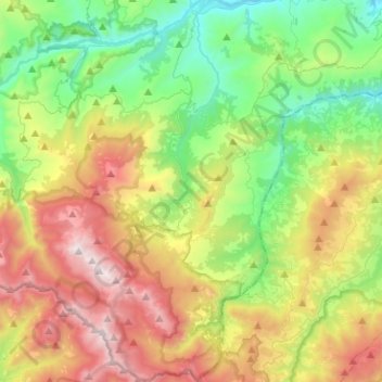
Nombre: Mapa topográfico Villa Minozzo, altitud, relieve.
Altitud media: 1.001 m
Altitud mínima: 350 m
Altitud máxima: 2.087 m
Gracias por apoyar a este sitio ❤️
Haz una donación
Haz una donación
Otros mapas topográficos
Haga clic en un mapa para ver su topografía, su altitud y su relieve.
Terminaccio
Italy > Emilia-Romagna > Reggio nell'Emilia > Castelnovo ne' Monti > Garfagnolo
Altitud media: 706 m
Gracias por apoyar a este sitio ❤️
Haz una donación
Haz una donación
Gracias por apoyar a este sitio ❤️
Haz una donación
Haz una donación