
Haz una donación
Mapa topográfico Lutsen
Haga clic en el mapa para ver la altitud.
Haz una donación
Acerca de este mapa
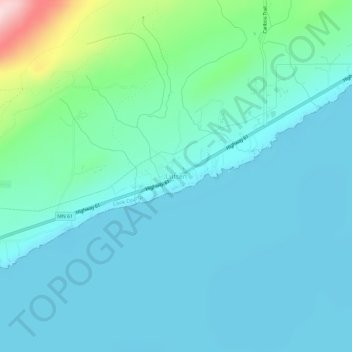
Nombre: Mapa topográfico Lutsen, altitud, relieve.
Altitud media: 225 m
Altitud mínima: 174 m
Altitud máxima: 496 m
Haz una donación
Otros mapas topográficos
Haga clic en un mapa para ver su topografía, su altitud y su relieve.
Pigeon River
United States > Minnesota > Cook County
The Pigeon River originates from a chain of lakes along the US-Canada border, the highest of which, and furthest west, is Mountain Lake. Among the Pigeon's tributaries is the Arrow River of Ontario, which rises in South Lake, west of and at a lower elevation than Mountain Lake. South Lake is separated only by…
Altitud media: 390 m
Haz una donación
Brule Lake
United States > Minnesota > Cook County > West Cook
Brule Lake lies in a region which has seen human population since the end of the last ice age. It has variously been within the territory of the Dakota, Cree, Ojibwa, French, British, and Americans. It saw little development until the opening of a railroad that allowed loggers easier access to the interior of…
Altitud media: 579 m
Haz una donación
Haz una donación