
Mapa topográfico Sahune
Mapa interactivo
Haga clic en el mapa para ver la altitud.
Acerca de este mapa
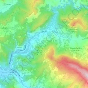
Nombre: Mapa topográfico Sahune, altitud, relieve.
Altitud media: 586 m
Altitud mínima: 317 m
Altitud máxima: 1.216 m
Der Ort Sahune liegt an einer Bergflanke oberhalb des Tales der Eygues im Südwesten des Départements Drôme, nahe der Grenze zum Département Vaucluse in einer Höhe von ca. 350 bis 400 m ü. d. M.; die nächstgrößere Stadt, Nyons, befindet sich ca. 16 km (Fahrtstrecke) südwestlich.