
Mapa topográfico Kalymnos
Mapa interactivo
Haga clic en el mapa para ver la altitud.
Kalymnos
Kalymnos is mostly mountainous with complicated topography. There are three main chains going from W-NW to E-SE, and a fourth which extends NW the length of the peninsula. The coastline is very irregular, with many sheltered coves. There are some springs, one among them being thermal. The soil is mainly limestone-based, but in the valleys, there is a compact bank of volcanic tuff, the relic of an ancient volcano, located in Vigles, between the villages of Myrties and Kantouni. The island is mainly barren, except for the two fertile valleys of Vathys and Pothia, where olives, oranges and vines are grown. There is also an ostrich farm in Argos, near the airport.
Acerca de este mapa
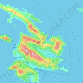
Nombre: Mapa topográfico Kalymnos, altitud, relieve.
Altitud media: 75 m
Altitud mínima: 0 m
Altitud máxima: 664 m
Otros mapas topográficos
Haga clic en un mapa para ver su topografía, su altitud y su relieve.