
Gracias por apoyar a este sitio ❤️
Haz una donación
Haz una donación
Mapa topográfico Nebelhorn
Haga clic en el mapa para ver la altitud.
Gracias por apoyar a este sitio ❤️
Haz una donación
Haz una donación
Acerca de este mapa
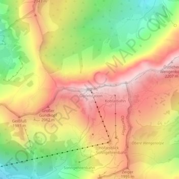
Nombre: Mapa topográfico Nebelhorn, altitud, relieve.
Lugar: Nebelhorn, Oberstdorf, Landkreis Oberallgäu, Bavaria, Germany (47.42182 10.34230 47.42192 10.34240)
Altitud media: 1.792 m
Altitud mínima: 1.318 m
Altitud máxima: 2.209 m
Gracias por apoyar a este sitio ❤️
Haz una donación
Haz una donación
Otros mapas topográficos
Haga clic en un mapa para ver su topografía, su altitud y su relieve.
Gracias por apoyar a este sitio ❤️
Haz una donación
Haz una donación
Gracias por apoyar a este sitio ❤️
Haz una donación
Haz una donación
Weitnau
Germany > Bavaria > Landkreis Oberallgäu
• Argental Skilifte; Two ski lifts offer well-prepared pistes for beginners and seasoned skiers and snowboarders. The 500-metre-long family lift, a modern T-bar lift with a difference in altitude of 120 metres, was completely rebuilt in the early 2000s. In addition, there is a 100-metre beginners lift with a…
Altitud media: 887 m