
Gracias por apoyar a este sitio ❤️
Haz una donación
Haz una donación
Mapa topográfico Yampil
Haga clic en el mapa para ver la altitud.
Gracias por apoyar a este sitio ❤️
Haz una donación
Haz una donación
Yampil
The city is located along Horyn River, a tributary of the Pripyat, and is part of the Podolsk Plateau [uk], while straddling the border with Lesser Polissia.[uk] Yampol is located in the more elevated part of Khmelnytskyi Oblast, in the Volyn highlands, where the average elevation is 329 meters above sea level.
Gracias por apoyar a este sitio ❤️
Haz una donación
Haz una donación
Acerca de este mapa
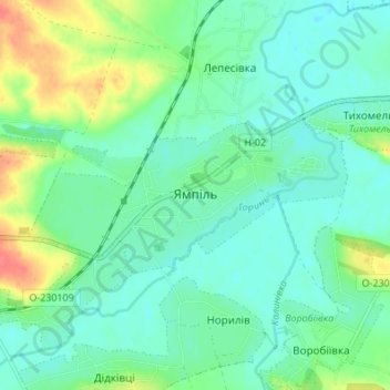
Nombre: Mapa topográfico Yampil, altitud, relieve.
Altitud media: 253 m
Altitud mínima: 238 m
Altitud máxima: 292 m
Gracias por apoyar a este sitio ❤️
Haz una donación
Haz una donación
Otros mapas topográficos
Haga clic en un mapa para ver su topografía, su altitud y su relieve.