
Haz una donación
Mapa topográfico Bodie
Haga clic en el mapa para ver la altitud.
Haz una donación
Bodie
Bodie (/ˈboʊdiː/ BOH-dee) is a ghost town in the Bodie Hills east of the Sierra Nevada mountain range in Mono County, California, United States. It is about 75 miles (121 km) southeast of Lake Tahoe, and 12 mi (19 km) east-southeast of Bridgeport, at an elevation of 8,379 feet (2554 m). Bodie became a boom town in 1876 (148 years ago) (1876) after the discovery of a profitable vein of gold; by 1879 it had established 2,000 structures with a population of roughly 8,000 people.
Haz una donación
Acerca de este mapa
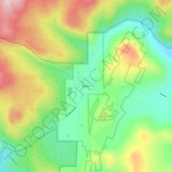
Nombre: Mapa topográfico Bodie, altitud, relieve.
Lugar: Bodie, Mono County, California, United States (38.19149 -119.03259 38.23149 -118.99259)
Altitud media: 2.627 m
Altitud mínima: 2.487 m
Altitud máxima: 2.821 m
Haz una donación
Otros mapas topográficos
Haga clic en un mapa para ver su topografía, su altitud y su relieve.
Mammoth Lakes
United States > California > Mono County
Mammoth Lakes is a town in Mono County, California, and is the county's only incorporated community. It is located immediately to the east of Mammoth Mountain, at an elevation of 7,880 feet (2,400 m). As of the 2020 United States Census, the population was 7,191, reflecting a 12.7% decrease from the 2010…
Altitud media: 2.682 m