
Mapa topográfico Reigate
Haga clic en el mapa para ver la altitud.
Reigate
Reigate is in central Surrey, around 19 mi (30 km) south of central London and 9 mi (14 km) north of Gatwick Airport. The town is in the Vale of Holmesdale, below the North Downs escarpment. The average elevation in the centre is 80 m (260 ft) above ordnance datum (OD) and the area is drained by the Wallace Brook and its tributaries, which feed the River Mole.
Acerca de este mapa
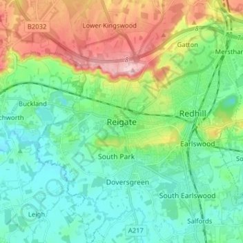
Nombre: Mapa topográfico Reigate, altitud, relieve.
Altitud media: 100 m
Altitud mínima: 43 m
Altitud máxima: 236 m
Otros mapas topográficos
Haga clic en un mapa para ver su topografía, su altitud y su relieve.
Lower Earlswood Lake
United Kingdom > England > Surrey > Reigate and Banstead > Redhill
Altitud media: 75 m
Banstead Wood
United Kingdom > England > Surrey > Reigate and Banstead > Chipstead
Altitud media: 145 m
Horley
United Kingdom > England > Surrey > Reigate and Banstead
Horley is at an altitude of around 54 m (177 ft) above mean sea level.
Altitud media: 58 m