
Gracias por apoyar a este sitio ❤️
Haz una donación
Haz una donación
Mapa topográfico Königstein im Taunus
Haga clic en el mapa para ver la altitud.
Gracias por apoyar a este sitio ❤️
Haz una donación
Haz una donación
Acerca de este mapa
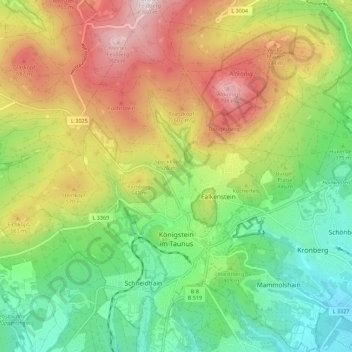
Nombre: Mapa topográfico Königstein im Taunus, altitud, relieve.
Lugar: Königstein im Taunus, Hochtaunuskreis, Hesse, 61462, Germany (50.15888 8.41189 50.23037 8.51369)
Altitud media: 451 m
Altitud mínima: 171 m
Altitud máxima: 852 m
Gracias por apoyar a este sitio ❤️
Haz una donación
Haz una donación
Otros mapas topográficos
Haga clic en un mapa para ver su topografía, su altitud y su relieve.
Großer Feldberg
Germany > Hesse > Hochtaunuskreis > Schmitten im Taunus
The Großer Feldberg ('Great Field Mountain') is, at a height of 879.5 metres, the highest elevation of the Taunus mountains, and of the entire Rhenish Massif. It is situated in the Hochtaunuskreis district in Hesse, Germany.
Altitud media: 716 m
Saubach und Niedgesbach bei Schmitten
Germany > Hesse > Hochtaunuskreis > Finsternthal
Altitud media: 549 m