
Gracias por apoyar a este sitio ❤️
Haz una donación
Haz una donación
Mapa topográfico Nordviertel
Haga clic en el mapa para ver la altitud.
Gracias por apoyar a este sitio ❤️
Haz una donación
Haz una donación
Nordviertel
Nordviertel has 7,308 inhabitants and is therefore one of the smallest boroughs of Essen. It has an area of 2.86 km² and its average elevation is 48 metres above sea level.
Gracias por apoyar a este sitio ❤️
Haz una donación
Haz una donación
Acerca de este mapa
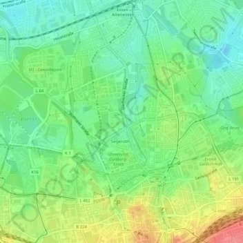
Nombre: Mapa topográfico Nordviertel, altitud, relieve.
Altitud media: 62 m
Altitud mínima: 33 m
Altitud máxima: 111 m
Gracias por apoyar a este sitio ❤️
Haz una donación
Haz una donación