
Haz una donación
Mapa topográfico Migliana
Haga clic en el mapa para ver la altitud.
Haz una donación
Acerca de este mapa
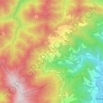
Nombre: Mapa topográfico Migliana, altitud, relieve.
Altitud media: 589 m
Altitud mínima: 150 m
Altitud máxima: 971 m
Haz una donación
Otros mapas topográficos
Haga clic en un mapa para ver su topografía, su altitud y su relieve.
Prato
Prato (/ˈprɑːtoʊ/ PRAH-toh; Italian: [ˈpraːto] ) is a city and municipality (comune) in Tuscany, Italy, and is the capital of the province of Prato. The city lies in the northeast of Tuscany, at an elevation of 65 metres (213 ft), at the foot of Monte Retaia (the last peak in the Calvana chain). With…
Altitud media: 148 m
Haz una donación