
Gracias por apoyar a este sitio ❤️
Haz una donación
Haz una donación
Mapa topográfico Indio
Haga clic en el mapa para ver la altitud.
Gracias por apoyar a este sitio ❤️
Haz una donación
Haz una donación
Indio
Indio is home of Riverside County's eastern administration offices. Palm Springs had more people from 1955 to 1992, when the US census announced that Indio surpassed Palm Springs and that title was returned to them. The official elevation of Indio is below sea level; the city hall is 14 feet (4 m) below sea level, as the eastern half of the Coachella Valley drops as low as 150 feet (50 m) below sea level (the lakeshore of the Salton Sea is 15 miles (24 km) south of Indio).
Gracias por apoyar a este sitio ❤️
Haz una donación
Haz una donación
Acerca de este mapa
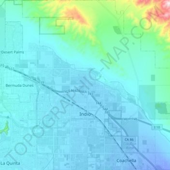
Nombre: Mapa topográfico Indio, altitud, relieve.
Lugar: Indio, Riverside County, California, United States (33.67100 -116.30127 33.81654 -116.16414)
Altitud media: 70 m
Altitud mínima: -30 m
Altitud máxima: 696 m
Gracias por apoyar a este sitio ❤️
Haz una donación
Haz una donación