
Haz una donación
Mapa topográfico Vetulonia
Haga clic en el mapa para ver la altitud.
Haz una donación
Acerca de este mapa
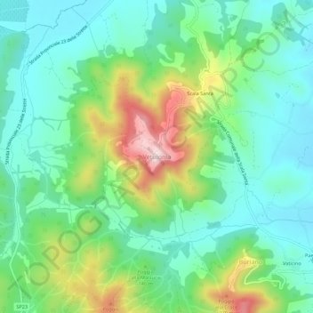
Nombre: Mapa topográfico Vetulonia, altitud, relieve.
Altitud media: 106 m
Altitud mínima: 9 m
Altitud máxima: 337 m
Haz una donación
Otros mapas topográficos
Haga clic en un mapa para ver su topografía, su altitud y su relieve.
Seggiano
With the exception of units of low hill near the beds of rivers, the region extends mainly in hilly and mountainous odds, but good exposure allows the cultivation of a cultivar of olive, Olivastra Seggianese, called up to elevations of low mountains, managing to produce an oil of excellent quality.
Altitud media: 550 m
Haz una donación
Haz una donación
Pitigliano
The municipality area of Pitigliano, while presenting different local situations on the basis of 'topography is characterized by rather low winter temperatures, which can occur during prolonged periods, despite the daily maximum values are often pleasing. On the contrary, in summer the heat can be very…
Altitud media: 331 m
Haz una donación