
Mapa topográfico Lancaster
Mapa interactivo
Haga clic en el mapa para ver la altitud.
Acerca de este mapa
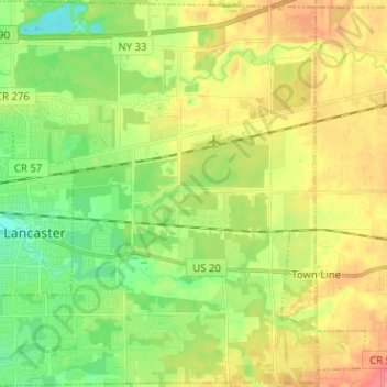
Nombre: Mapa topográfico Lancaster, altitud, relieve.
Altitud media: 224 m
Altitud mínima: 194 m
Altitud máxima: 262 m
Otros mapas topográficos
Haga clic en un mapa para ver su topografía, su altitud y su relieve.
East Lancaster
United States > New York > Erie County > Town of Lancaster
East Lancaster, Town of Lancaster, Erie County, New York, 14086, United States
Altitud media: 216 m
Bowmansville
United States > New York > Erie County > Town of Lancaster
Bowmansville, Town of Lancaster, Erie County, New York, 14026, United States
Altitud media: 215 m
Village of Depew
United States > New York > Erie County > Town of Lancaster
Village of Depew, Town of Lancaster, Erie County, New York, 14043, United States
Altitud media: 208 m