
Gracias por apoyar a este sitio ❤️
Haz una donación
Haz una donación
Mapa topográfico Aue
Haga clic en el mapa para ver la altitud.
Gracias por apoyar a este sitio ❤️
Haz una donación
Haz una donación
Acerca de este mapa
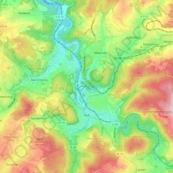
Nombre: Mapa topográfico Aue, altitud, relieve.
Lugar: Aue, Aue-Bad Schlema, Erzgebirgskreis, Saxony, 08280, Germany (50.56151 12.65549 50.63743 12.73984)
Altitud media: 465 m
Altitud mínima: 315 m
Altitud máxima: 657 m
Gracias por apoyar a este sitio ❤️
Haz una donación
Haz una donación
Otros mapas topográficos
Haga clic en un mapa para ver su topografía, su altitud y su relieve.
Markersbach
Germany > Saxony > Erzgebirgskreis
In 1889, Markersbach was connected to the railway line from Schwarzenberg to Annaberg, which was closed to passenger transport on 27 September 1997. The station lay in Mittweida’s municipal area and the platform signs read Mittweida-Markersbach. To overcome the great elevation differential, the railway's…
Altitud media: 600 m
Gracias por apoyar a este sitio ❤️
Haz una donación
Haz una donación