
Mapa topográfico Grand Coulee Dam
Mapa interactivo
Haga clic en el mapa para ver la altitud.
Acerca de este mapa
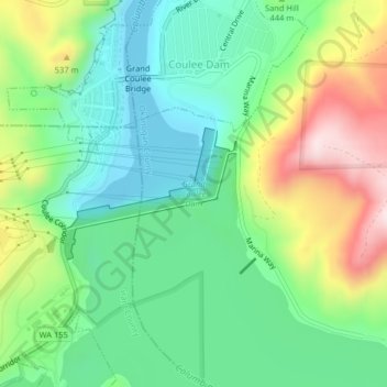
Nombre: Mapa topográfico Grand Coulee Dam, altitud, relieve.
Altitud media: 423 m
Altitud mínima: 291 m
Altitud máxima: 676 m
After power shortages in the Northwest during the 1960s, it was determined the six remaining planned pumps be pump-generators. When energy demand is high, the pump-generators can generate electricity with water from the Banks Lake feeder canal adjacent to the dam at a higher elevation. By 1973, the Pump-Generating Plant was completed and the first two generators (P/G-7 and P/G-8) were operational. In 1983, two more generators went online, and by January 1984 the final two were operational. The six pump-generators added 314 MW to the dam's capacity. In May 2009, the Pump-Generating Plant was officially renamed the John W. Keys III Pump-Generating Power Plant after John W. Keys III, the U.S. Bureau of Reclamation's commissioner from 2001 to 2006.