
Haz una donación
Mapa topográfico Bolzano - Bozen
Haga clic en el mapa para ver la altitud.
Haz una donación
Bolzano - Bozen
The area of the city of Bolzano is 52.3 km2 (20.2 sq mi), of which 28 km2 (11 sq mi) is used as a settlement area. The city is located in the basin where the Sarntal, Eisacktal, and the Adige Valley with their rivers, Talfer, Eisack, and Adige, meet. In the Middle Ages, the two main Alpine crossings, the Via Claudia Augusta over Reschenpass and the Brenner route over Brenner Pass, met in Bolzano. Thus, the city was very important for trading. The highest point is 1,616 metres (5,302 feet) above sea level and the lowest point is 232 metres (761 feet) above sea level. The centre is located at an altitude of 262 metres (860 feet) above sea level. The nearest big cities are 58 km (36 mi) (Trento) and 118 km (73 mi) (Innsbruck) away.
Haz una donación
Acerca de este mapa
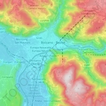
Nombre: Mapa topográfico Bolzano - Bozen, altitud, relieve.
Altitud media: 716 m
Altitud mínima: 221 m
Altitud máxima: 1.613 m
Haz una donación
Otros mapas topográficos
Haga clic en un mapa para ver su topografía, su altitud y su relieve.
Sulden - Solda
Italy > Trentino – Alto Adige/Südtirol > South Tyrol > Stilfs - Stelvio
Altitud media: 2.232 m
Welsberg - Monguelfo
Italy > Trentino – Alto Adige/Südtirol > South Tyrol > Welsberg-Taisten - Monguelfo-Tesido
Altitud media: 1.289 m
Obereggen - San Floriano d'Ega
Italy > Trentino – Alto Adige/Südtirol > South Tyrol > Deutschnofen - Nova Ponente
Altitud media: 1.650 m
Gufidaun - Gudon
Italy > Trentino – Alto Adige/Südtirol > South Tyrol > Klausen - Chiusa
Altitud media: 860 m
Haz una donación
Secëda - Monte Seceda
Italy > Trentino – Alto Adige/Südtirol > South Tyrol > Santa Cristina Gherdëina - St. Christina in Gröden - Santa Cristina Valgardena
Monte Seceda is a 2,519-meter-elevation (8,264-foot) summit in the Odles Group of the Dolomites, a UNESCO World Heritage Site. Set in the Trentino-Alto Adige/Südtirol region, the peak is located four kilometers (2.5 miles) north of the village of Santa Cristina Gherdëina, and the peak is in Puez-Geisler…
Altitud media: 2.106 m
Flading - Vallettina
Italy > Trentino – Alto Adige/Südtirol > South Tyrol > Ratschings - Racines
Altitud media: 2.012 m
Funtanacia
Italy > Trentino – Alto Adige/Südtirol > South Tyrol > La Ila - Stern - La Villa
Altitud media: 1.787 m
Haz una donación
Schlern - Sciliar
Italy > Trentino – Alto Adige/Südtirol > South Tyrol > Völs am Schlern - Fiè allo Sciliar
Altitud media: 2.033 m
Grünsee - Lago Verde
Italy > Trentino – Alto Adige/Südtirol > South Tyrol > Ulten - Ultimo
Altitud media: 2.683 m
Haz una donación
Schmieden - Ferrara
Italy > Trentino – Alto Adige/Südtirol > South Tyrol > Prags - Braies
Altitud media: 1.426 m
Antlas
Italy > Trentino – Alto Adige/Südtirol > South Tyrol > Ritten - Renon > Atzwang - Campodazzo
Altitud media: 818 m
Nock
Italy > Trentino – Alto Adige/Südtirol > South Tyrol > Ratschings - Racines
Altitud media: 1.795 m
Gherdëina - Grödnertal - Val Gardena
Italy > Trentino – Alto Adige/Südtirol > South Tyrol > Urtijëi - St. Ulrich in Gröden - Ortisei
Altitud media: 1.607 m
Haz una donación
Tierseralpl - Alpe di Tires
Italy > Trentino – Alto Adige/Südtirol > South Tyrol > Tiers - Tires
Altitud media: 2.285 m
Haz una donación
Schluderbach - Carbonin
Italy > Trentino – Alto Adige/Südtirol > South Tyrol > Toblach - Dobbiaco
Altitud media: 1.776 m
Haz una donación
Langtauferer Tal - Vallelunga
Italy > Trentino – Alto Adige/Südtirol > South Tyrol > Graun - Curon Venosta
Altitud media: 2.513 m
St. Georg - San Giorgio di Eores
Italy > Trentino – Alto Adige/Südtirol > South Tyrol > Brixen - Bressanone
Altitud media: 1.476 m
St. Anton - Sant'Antonio
Italy > Trentino – Alto Adige/Südtirol > South Tyrol > St. Nikolaus - San Nicolò
Altitud media: 745 m
Haz una donación
Schneespitz - Cima della Neve
Italy > Trentino – Alto Adige/Südtirol > South Tyrol > Predoi
Altitud media: 2.497 m
Costadedoi
Italy > Trentino – Alto Adige/Südtirol > South Tyrol > San Ćiascian - St. Kassian - San Cassiano
Altitud media: 1.712 m
Obereggen - San Floriano d'Ega
Italy > Trentino – Alto Adige/Südtirol > South Tyrol > Deutschnofen - Nova Ponente
Altitud media: 1.650 m
Haz una donación
St. Magdalena - Santa Maddalena in Casies
Italy > Trentino – Alto Adige/Südtirol > South Tyrol > Gsies - Valle di Casies
Altitud media: 1.772 m
Croda del Becco - Sas dla Porta - Seekofel
Italy > Trentino – Alto Adige/Südtirol > South Tyrol > Prags - Braies
Altitud media: 2.186 m
Lengmoos - Longomoso
Italy > Trentino – Alto Adige/Südtirol > South Tyrol > Ritten - Renon > Klobenstein - Collalbo
Altitud media: 1.049 m
Haz una donación
Hoher Weißzint - Punta Bianca
Italy > Trentino – Alto Adige/Südtirol > South Tyrol > Mühlwald - Selva dei Molini
Altitud media: 2.905 m
Haz una donación
Turnerkamp - Cima di Campo
Italy > Trentino – Alto Adige/Südtirol > South Tyrol > Mühlwald - Selva dei Molini
Altitud media: 2.868 m
St. Anton - Sant'Antonio
Italy > Trentino – Alto Adige/Südtirol > South Tyrol > St. Nikolaus - San Nicolò
Altitud media: 745 m
Ortler - Ortles
Italy > Trentino – Alto Adige/Südtirol > South Tyrol > Stilfs - Stelvio
The Ortler was first climbed by Josef Pichler [de] ("Pseirer-Josele"), a chamois hunter from St. Leonhard in Passeier, and his companions Johann Leitner and Johann Klausner from Zell am Ziller on 27 September 1804. The ascent had been a request of Archduke Johann of Austria, who felt strongly that after the…
Altitud media: 3.175 m
Sulden - Solda
Italy > Trentino – Alto Adige/Südtirol > South Tyrol > Stilfs - Stelvio
Altitud media: 2.232 m
Haz una donación
Atzwang - Campodazzo
Italy > Trentino – Alto Adige/Südtirol > South Tyrol > Ritten - Renon
Altitud media: 786 m
Grube - Fossa
Italy > Trentino – Alto Adige/Südtirol > South Tyrol > Oberradein - Redagno di Sopra
Altitud media: 1.477 m
Haz una donación
Roen
Italy > Trentino – Alto Adige/Südtirol > South Tyrol > Tramin an der Weinstraße - Termeno sulla Strada del Vino
Altitud media: 1.740 m
Maring
Italy > Trentino – Alto Adige/Südtirol > South Tyrol > La Ila - Stern - La Villa
Altitud media: 1.727 m
Villa Nöia
Italy > Trentino – Alto Adige/Südtirol > South Tyrol > La Ila - Stern - La Villa
Altitud media: 1.632 m
Graun im Vinschgau - Curon Venosta
Italy > Trentino – Alto Adige/Südtirol > South Tyrol > Graun - Curon Venosta
Altitud media: 1.794 m
Haz una donación
Kühwiesenkopf - Monte Prà della Vacca
Italy > Trentino – Alto Adige/Südtirol > South Tyrol > Prags - Braies
Altitud media: 1.854 m
Mitterdorf - Caldaro di Mezzo
Italy > Trentino – Alto Adige/Südtirol > South Tyrol > St. Nikolaus - San Nicolò
Altitud media: 664 m
Seis am Schlern - Siusi allo Sciliar
Italy > Trentino – Alto Adige/Südtirol > South Tyrol > Kastelruth - Castelrotto
Altitud media: 1.211 m
Haz una donación
Reschen - Resia
Italy > Trentino – Alto Adige/Südtirol > South Tyrol > Graun - Curon Venosta
Altitud media: 1.814 m
St. Magdalena - Santa Maddalena in Casies
Italy > Trentino – Alto Adige/Südtirol > South Tyrol > Gsies - Valle di Casies
Altitud media: 1.772 m
Haz una donación
Telfen - Lanzin
Italy > Trentino – Alto Adige/Südtirol > South Tyrol > Kastelruth - Castelrotto > Kastelruth - Ciastel - Castelrotto
Altitud media: 1.035 m
Ortler - Ortles
Italy > Trentino – Alto Adige/Südtirol > South Tyrol > Stilfs - Stelvio
The Ortler was first climbed by Josef Pichler [de] ("Pseirer-Josele"), a chamois hunter from St. Leonhard in Passeier, and his companions Johann Leitner and Johann Klausner from Zell am Ziller on 27 September 1804. The ascent had been a request of Archduke Johann of Austria, who felt strongly that after the…
Altitud media: 3.175 m
Sulden - Solda
Italy > Trentino – Alto Adige/Südtirol > South Tyrol > Stilfs - Stelvio
Altitud media: 2.232 m
Hintere Schwärze
Italy > Trentino – Alto Adige/Südtirol > South Tyrol > Schnals - Senales
Altitud media: 3.152 m
Haz una donación
Kampenn - Campegno
Italy > Trentino – Alto Adige/Südtirol > South Tyrol > Bolzano > Rentsch - Rencio
Altitud media: 670 m
Seis am Schlern - Siusi allo Sciliar
Italy > Trentino – Alto Adige/Südtirol > South Tyrol > Kastelruth - Castelrotto
Altitud media: 1.211 m
Haz una donación
Dörfl
Italy > Trentino – Alto Adige/Südtirol > South Tyrol > Gsies - Valle di Casies > St. Magdalena - Santa Maddalena in Casies
Altitud media: 1.770 m
Steinhaus - Cadipietra
Italy > Trentino – Alto Adige/Südtirol > South Tyrol > Ahrntal - Valle Aurina
Altitud media: 1.491 m
Haz una donación
Weissenbach - Rio Bianco
Italy > Trentino – Alto Adige/Südtirol > South Tyrol > Sarntal - Sarentino
Altitud media: 1.718 m
Gherdëina - Grödnertal - Val Gardena
Italy > Trentino – Alto Adige/Südtirol > South Tyrol > Urtijëi - St. Ulrich in Gröden - Ortisei
Altitud media: 1.588 m
Saslonch - Langkofel - Sassolungo
Italy > Trentino – Alto Adige/Südtirol > South Tyrol > Sëlva - Wolkenstein - Selva di Val Gardena
Altitud media: 2.320 m
Haz una donación
Calfosch - Kolfuschg - Colfosco
Italy > Trentino – Alto Adige/Südtirol > South Tyrol
Altitud media: 1.931 m