
Gracias por apoyar a este sitio ❤️
Haz una donación
Haz una donación
Mapa topográfico Oberstenfeld
Haga clic en el mapa para ver la altitud.
Gracias por apoyar a este sitio ❤️
Haz una donación
Haz una donación
Oberstenfeld
Prevorst is an exclave located between the Heilbronn district and the Rems-Murr district. With an elevation of 482m it is the highest location of the Ludwigsburg district.
Gracias por apoyar a este sitio ❤️
Haz una donación
Haz una donación
Acerca de este mapa
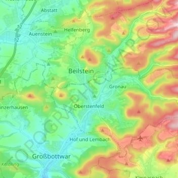
Nombre: Mapa topográfico Oberstenfeld, altitud, relieve.
Altitud media: 299 m
Altitud mínima: 212 m
Altitud máxima: 465 m
Gracias por apoyar a este sitio ❤️
Haz una donación
Haz una donación