
Mapa topográfico Nijlande
Mapa interactivo
Haga clic en el mapa para ver la altitud.
Acerca de este mapa
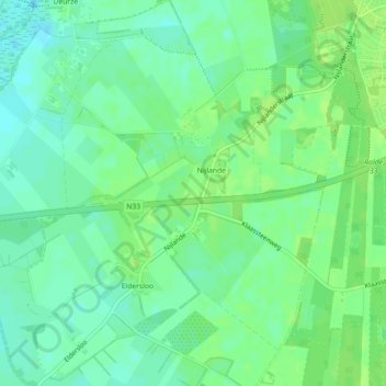
Nombre: Mapa topográfico Nijlande, altitud, relieve.
Lugar: Nijlande, Aa en Hunze, Drenthe, Nederland (52.96056 6.60896 52.98249 6.63972)
Altitud media: 15 m
Altitud mínima: 8 m
Altitud máxima: 20 m
Otros mapas topográficos
Haga clic en un mapa para ver su topografía, su altitud y su relieve.
Nooitgedacht
Nederland > Drenthe > Aa en Hunze
Nooitgedacht, Aa en Hunze, Drenthe, Nederland
Altitud media: 15 m
Annerveenschekanaal
Nederland > Drenthe > Aa en Hunze
Annerveenschekanaal, Aa en Hunze, Drenthe, Nederland
Altitud media: 2 m
Gieterveen
Nederland > Drenthe > Aa en Hunze > Gieterveen
Gieterveen, Aa en Hunze, Drenthe, Nederland, 9511, Nederland
Altitud media: 4 m
Bareveld
Nederland > Drenthe > Aa en Hunze > Bareveld
Bareveld, Aa en Hunze, Drenthe, Nederland, 9512, Nederland
Altitud media: 4 m
Vredenheim
Nederland > Drenthe > Aa en Hunze
Vredenheim, Aa en Hunze, Drenthe, Nederland
Altitud media: 16 m