
Mapa topográfico Warwick
Haga clic en el mapa para ver la altitud.
Warwick
Warwick experiences the usual English maritime climate, marked by a narrow temperature range, mild winters and cool summers. The nearest official Met Office weather station is at Wellesbourne, about 6 miles (10 km) south of the town centre and at a similar elevation. The absolute maximum temperature (also the absolute maximum for the county of Warwickshire) stands at 36.1 °C (97.0 °F) recorded in August 1990. During a typical year, the warmest day should reach 30.0 °C (86.0 °F), and 16.5 days should report a maximum of 25.1 °C (77.2 °F) or higher. The lowest recorded temperature is −17.8 °C (0.0 °F), recorded in January 1982. Typically, 53.3 air frosts are recorded in an "average" year. Rainfall averages out at 608 millimetres (23.9 in) per year, with over 114 days seeing 1 mm (0.04 in) or more falling. All averages refer to the 1971–2000 period.
Acerca de este mapa
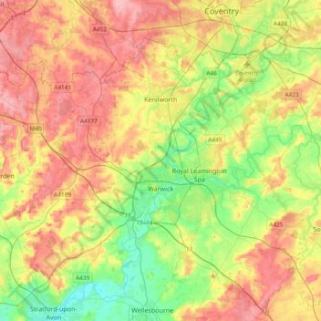
Nombre: Mapa topográfico Warwick, altitud, relieve.
Lugar: Warwick, Warwickshire, England, United Kingdom (52.21370 -1.78018 52.38928 -1.40608)
Altitud media: 87 m
Altitud mínima: 35 m
Altitud máxima: 145 m
Otros mapas topográficos
Haga clic en un mapa para ver su topografía, su altitud y su relieve.
Big Clowes Wood
United Kingdom > England > Warwickshire > Stratford-on-Avon > Tanworth in Arden CP
Altitud media: 152 m
Gilson
United Kingdom > England > Warwickshire > North Warwickshire > Coleshill CP
Altitud media: 82 m
Pooley Country Park
United Kingdom > England > Warwickshire > North Warwickshire > Polesworth
Altitud media: 76 m
Hampton on the Hill
United Kingdom > England > Warwickshire > Warwick > Hampton on the Hill
Altitud media: 75 m
Burton Dassett Hills Country Park
United Kingdom > England > Warwickshire > Stratford-on-Avon > Northend > Burton Dassett CP
Altitud media: 132 m
Upper Quinton
United Kingdom > England > Warwickshire > Stratford-on-Avon > Lower Quinton
Altitud media: 70 m
Lye Green
United Kingdom > England > Warwickshire > Stratford-on-Avon > Claverdon
Altitud media: 106 m
Hartshill Hayes Country Park
United Kingdom > England > Warwickshire > North Warwickshire > Ansley Common
Altitud media: 127 m
Cranhill
United Kingdom > England > Warwickshire > Stratford-on-Avon > Ardens Grafton
Altitud media: 57 m
Curdworth Locks
United Kingdom > England > Warwickshire > North Warwickshire > Kingsbury > Curdworth CP
Altitud media: 80 m
Oversley Wood
United Kingdom > England > Warwickshire > Stratford-on-Avon > Alcester > Exhall
Altitud media: 64 m
Merevale Lake
United Kingdom > England > Warwickshire > North Warwickshire > Atherstone
Altitud media: 119 m
Church End
United Kingdom > England > Warwickshire > North Warwickshire > Ansley CP
Altitud media: 151 m
Sutton-under-Brailes
United Kingdom > England > Warwickshire > Stratford-on-Avon > Stourton
Altitud media: 125 m
Brinklow Marina
United Kingdom > England > Warwickshire > Rugby > King's Newnham CP
Altitud media: 95 m
Vale View
United Kingdom > England > Warwickshire > Nuneaton and Bedworth > Nuneaton
Altitud media: 113 m
Arlescote
United Kingdom > England > Warwickshire > Stratford-on-Avon > Warmington CP
Altitud media: 148 m
Bishopton
United Kingdom > England > Warwickshire > Stratford-on-Avon > Stratford-upon-Avon
Altitud media: 64 m
Holbech's Wood
United Kingdom > England > Warwickshire > North Warwickshire > Fillongley CP
Altitud media: 140 m
Hoar Park
United Kingdom > England > Warwickshire > North Warwickshire > Bentley CP
Altitud media: 135 m
Hunts Green
United Kingdom > England > Warwickshire > North Warwickshire > Middleton CP
Altitud media: 81 m
Marlcliff
United Kingdom > England > Warwickshire > Stratford-on-Avon > Bidford on Avon CP
Altitud media: 41 m
River Avon
United Kingdom > England > Warwickshire > Stratford-on-Avon > Stratford-upon-Avon > Clifford Chambers
Altitud media: 43 m
Ashorne
United Kingdom > England > Warwickshire > Stratford-on-Avon > Moreton Morrell
Altitud media: 67 m
Pillerton Hersey
United Kingdom > England > Warwickshire > Stratford-on-Avon > Pillerton Hersey
Altitud media: 92 m
Lea Marston Purification Lakes
United Kingdom > England > Warwickshire > North Warwickshire > Marston
Altitud media: 70 m
Ladbroke (Millennium Green)
United Kingdom > England > Warwickshire > Stratford-on-Avon > Ladbroke CP
Altitud media: 98 m