
Gracias por apoyar a este sitio ❤️
Haz una donación
Haz una donación
Mapa topográfico Ries
Haga clic en el mapa para ver la altitud.
Gracias por apoyar a este sitio ❤️
Haz una donación
Haz una donación
Acerca de este mapa
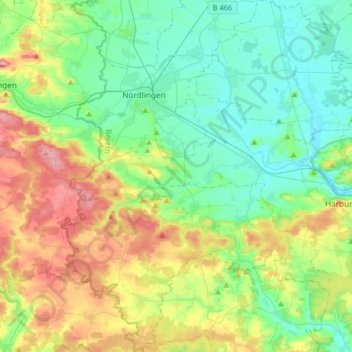
Nombre: Mapa topográfico Ries, altitud, relieve.
Lugar: Ries, Landkreis Donau-Ries, Bavaria, Germany (48.69473 10.41207 48.90927 10.68433)
Altitud media: 484 m
Altitud mínima: 404 m
Altitud máxima: 672 m
Gracias por apoyar a este sitio ❤️
Haz una donación
Haz una donación
Otros mapas topográficos
Haga clic en un mapa para ver su topografía, su altitud y su relieve.
Gracias por apoyar a este sitio ❤️
Haz una donación
Haz una donación
Rain
Germany > Bavaria > Landkreis Donau-Ries > Rain > Rain
The major cause of rain production is moisture moving along three-dimensional zones of temperature and moisture contrasts known as weather fronts. If enough moisture and upward motion is present, precipitation falls from convective clouds (those with strong upward vertical motion) such as cumulonimbus (thunder…
Altitud media: 405 m
Gracias por apoyar a este sitio ❤️
Haz una donación
Haz una donación