
Haz una donación
Mapa topográfico Cody
Haga clic en el mapa para ver la altitud.
Haz una donación
Cody
Cody's elevation is approximately 4,997 feet (1,523 m) above sea level. The main part of the city is split across three levels, separated by about 60 feet (18 m).
Haz una donación
Acerca de este mapa
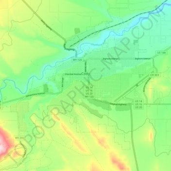
Nombre: Mapa topográfico Cody, altitud, relieve.
Lugar: Cody, Park County, Wyoming, United States (44.48981 -109.12048 44.55131 -109.00576)
Altitud media: 1.557 m
Altitud mínima: 1.436 m
Altitud máxima: 1.798 m
Haz una donación
Otros mapas topográficos
Haga clic en un mapa para ver su topografía, su altitud y su relieve.
Haz una donación
Druid Peak
United States > Wyoming > Park County
Druid Peak (elevation 9,577 feet (2,919 m)) is a moderate domed peak on the southern flank of the Absaroka Range in Yellowstone National Park. The peak lies just north of the Lamar River and Soda Butte Creek confluence at the head of the Lamar Valley. Prior to 1885, this summit was named Soda Hill by members…
Altitud media: 2.597 m
Haz una donación
Haz una donación
Hayden Valley
United States > Wyoming > Park County
A grassy valley, branching between low ridges, running from the river toward the center of the basin. A small stream rose in this valley, breaking through the ridges to the west in a deep cañon, and falling into the channel of the Yellowstone, which here bears in a northeast course, flowing in view as far as…
Altitud media: 2.373 m
Haz una donación