
Mapa topográfico Town of Anderson
Mapa interactivo
Haga clic en el mapa para ver la altitud.
Acerca de este mapa
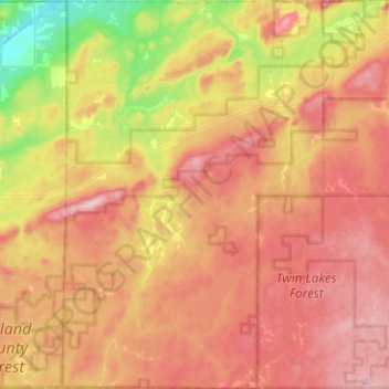
Nombre: Mapa topográfico Town of Anderson, altitud, relieve.
Lugar: Town of Anderson, Iron County, Wisconsin, United States (46.24060 -90.55177 46.41437 -90.38232)
Altitud media: 467 m
Altitud mínima: 342 m
Altitud máxima: 564 m
Otros mapas topográficos
Haga clic en un mapa para ver su topografía, su altitud y su relieve.
Montreal
United States > Wisconsin > Iron County
Montreal, Iron County, Wisconsin, United States
Altitud media: 464 m
Iron Belt
United States > Wisconsin > Iron County
Iron Belt, Town of Knight, Iron County, Wisconsin, 54536, United States
Altitud media: 475 m
Town of Gurney
United States > Wisconsin > Iron County
Town of Gurney, Iron County, Wisconsin, United States
Altitud media: 318 m
Powell
United States > Wisconsin > Iron County
Powell, Town of Sherman, Iron County, Wisconsin, United States
Altitud media: 487 m
Town of Pence
United States > Wisconsin > Iron County
Town of Pence, Iron County, Wisconsin, United States
Altitud media: 485 m
Saxon
United States > Wisconsin > Iron County
Saxon, Town of Saxon, Iron County, Wisconsin, 54559, United States
Altitud media: 339 m
Payment Lake
United States > Wisconsin > Iron County > Town of Mercer
Payment Lake, Town of Mercer, Iron County, Wisconsin, United States
Altitud media: 495 m
Upson
United States > Wisconsin > Iron County
Upson, Town of Anderson, Iron County, Wisconsin, United States
Altitud media: 462 m
Hurley
United States > Wisconsin > Iron County
Hurley, Iron County, Wisconsin, United States
Altitud media: 455 m
Town of Mercer
United States > Wisconsin > Iron County
Town of Mercer, Iron County, Wisconsin, 54547, United States
Altitud media: 493 m
Manitowish River
United States > Wisconsin > Iron County > Town of Mercer > Manitowish
Manitowish River, Manitowish, Town of Mercer, Iron County, Wisconsin, United States
Altitud media: 486 m