
Gracias por apoyar a este sitio ❤️
Haz una donación
Haz una donación
Mapa topográfico Clausthal-Zellerfeld
Haga clic en el mapa para ver la altitud.
Gracias por apoyar a este sitio ❤️
Haz una donación
Haz una donación
Clausthal-Zellerfeld
Clausthal-Zellerfeld (German pronunciation: [ˈklaʊstaːlˈtsɛlɐfɛlt] ) is a town in Lower Saxony, Germany. It is located in the southwestern part of the Harz mountains. Its population is approximately 15,000. The town hosts the Clausthal University of Technology. The health resort is located in the Upper Harz at an altitude between 390 and 821 m above sea level.
Gracias por apoyar a este sitio ❤️
Haz una donación
Haz una donación
Acerca de este mapa
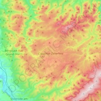
Nombre: Mapa topográfico Clausthal-Zellerfeld, altitud, relieve.
Lugar: Clausthal-Zellerfeld, Landkreis Goslar, Lower Saxony, Germany (51.76580 10.26828 51.85812 10.57888)
Altitud media: 466 m
Altitud mínima: 153 m
Altitud máxima: 907 m
Gracias por apoyar a este sitio ❤️
Haz una donación
Haz una donación
Otros mapas topográficos
Haga clic en un mapa para ver su topografía, su altitud y su relieve.