
Haz una donación
Mapa topográfico Ojai
Haga clic en el mapa para ver la altitud.
Haz una donación
Ojai
The Ojai Valley lies within the Topatopa Mountains on the north and south and is actively shaped by a web of earthquake faults. The Sisar fault in the valley was the epicenter of a magnitude 5.1 earthquake on August 20, 2023. The Santa Ynez Mountains lie to the north, while Sulphur Mountain and the lower Black Mountain lie to the south. Nordhoff Ridge, the western extension of the Topatopa Mountains, towers over the north side of the valley at more than 5,000 feet (1,500 m). Sulphur Mountain creates the southern ranges bounding the Ojai Valley, a little under 3,000 feet (910 m) in elevation. The Sulphur and Topatopa mountains are part of the Transverse Ranges system. The Ojai Valley and the surrounding mountains are heavily wooded with oak trees.
Haz una donación
Acerca de este mapa
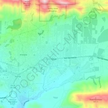
Nombre: Mapa topográfico Ojai, altitud, relieve.
Lugar: Ojai, Ventura County, California, 93023, United States (34.42924 -119.27457 34.47065 -119.22062)
Altitud media: 289 m
Altitud mínima: 180 m
Altitud máxima: 592 m
Haz una donación
Otros mapas topográficos
Haga clic en un mapa para ver su topografía, su altitud y su relieve.